Category:PEF map of Western Palestine (details of sheet 10)
Jump to navigation
Jump to search
Media in category "PEF map of Western Palestine (details of sheet 10)"
The following 14 files are in this category, out of 14 total.
-
-
 Bahret Katurieh.JPG 1,076 × 756; 421 KB
-
 Bir Ghaneim, 'Ayun el Werdat.png 1,310 × 541; 1.15 MB
-
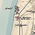 Historical map series for the area of al-Haram, Jaffa (1870s).jpg 741 × 745; 156 KB
-
 Historical map series for the area of Bayyarat Hannun (1870s).jpg 742 × 746; 167 KB
-
 Historical map series for the area of Ghabat Kafr Sur (1870s).jpg 742 × 746; 183 KB
-
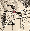 Historical map series for the area of Kafr Saba (1870s).jpg 741 × 745; 199 KB
-
 Historical map series for the area of Khirbat al-Zababida (1870s).jpg 742 × 745; 185 KB
-
 Historical map series for the area of Khirbat Bayt Lid (1870s).jpg 742 × 746; 221 KB
-
 Historical map series for the area of Miska, Tulkarm (1870s).jpg 742 × 745; 241 KB
-
 Historical map series for the area of Tabsur (1870s).jpg 741 × 745; 225 KB
-
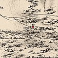
 Historical map series for the area of Umm Khalid (1870s).jpg 742 × 746; 166 KB
-
 Historical map series for the area of Wadi al-Hawarith (1870s).jpg 743 × 747; 75 KB
-
 Historical map series for the area of Wadi Qabbani (1870s).jpg 743 × 746; 145 KB
.jpg)


.jpg)
.jpg)
.jpg)
.jpg)
.jpg)
.jpg)
.jpg)
.jpg)
.jpg)
.jpg)
.jpg)