Category:Old road maps of Paris
Jump to navigation
Jump to search
Subcategories
This category has the following 13 subcategories, out of 13 total.
N
P
Media in category "Old road maps of Paris"
The following 35 files are in this category, out of 35 total.
-
 C. Picquet, Plan routier de la ville de Paris, 1821 - Gallica.jpg 11,167 × 7,363; 49.79 MB
-
 Nouveau plan routier de la ville de Paris, 1829 - Stanford Libraries.jpg 15,850 × 11,952; 75.9 MB
-
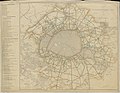
 1830 map of the environs of Paris.jpg 19,807 × 20,045; 122.16 MB
-
 Carte routiere des environs de Paris, 1839 - Stanford Libraries.jpg 14,152 × 9,528; 23.03 MB
-
 Carte routière des environs de Paris.jpg 7,416 × 5,376; 7.32 MB
-

-
 18th-century map - Paris - Plan routier de la ville de Paris et de ses faubourgs.jpg 8,240 × 6,476; 9.33 MB
-
 Achin, Nouvelle carte routière du voyageur aux environs de Paris, 1839.jpg 6,694 × 6,603; 21.96 MB
-
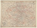
 Carte du département de la Seine - Routes - 1902.jpg 9,031 × 7,013; 13.39 MB
-
 Carte routière des environs de Paris, 1839 - Gallica.jpg 10,039 × 7,107; 16.38 MB
-
 Carte routière des environs de Paris... - Norman B. Leventhal Map Center.jpg 7,722 × 5,419; 9.96 MB
-
 Carte routière des environs de Paris... - Norman B. Leventhal Map Center.tif 7,722 × 5,419; 119.75 MB
-
 Environs de Paris by A. Buhlmann - Stanford Libraries.jpg 14,567 × 12,549; 32.25 MB
-
 Environs de Paris. Carte routière. Routes vélocipédiques. Vers 1893 - BHVP.jpg 5,636 × 4,380; 17.66 MB
-

-
 Esnault, Nouveau Plan Routier De La Ville De Paris Et De Ses Faubourgs, 1811 - David Rumsey.jpg 26,736 × 16,582; 162.19 MB
-
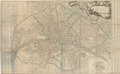
 Jean-Baptiste Crépy, Nouveau Plan routier de la ville et faubourg de Paris, 1750 - Gallica.jpg 11,058 × 8,334; 18.19 MB
-

-
 Jean-Baptiste Nolin, Plan Routier de la Ville de Paris et de ses Faubourgs, 1699 - Gallica.jpg 10,187 × 6,287; 15.8 MB
-
 Jean-Baptiste Nolin, Plan routier de la ville et faubourg de Paris, 1761 - Gallica.jpg 10,596 × 7,997; 15.97 MB
-
 Jean-Baptiste Nolin, Plan routier de la ville et faubourgs de Paris, 1744 - Gallica.jpg 8,566 × 6,566; 13.9 MB
-
 Nouveau plan routier de la ville & faubourgs de Paris, ca. 1800 - Stanford Libraries.jpg 16,917 × 10,379; 32.02 MB
-
 Nouveau plan routier de la ville & faubourgs de Paris, ca. 1800 - Stanford Libraries.tif 16,917 × 10,379; 167.45 MB
-

-
 Nouveau plan routier de la ville et faubourgs de Paris, ca. 1810-1812 - Stanford Libraries.tiff 5,337 × 4,116; 20.98 MB
-
 Nouvelle Carte Routière Des Environs De Paris.jpg 7,136 × 5,398; 11.87 MB
-
 Paris - Umgebung mit Verkehrswegen.jpg 7,580 × 6,204; 17.35 MB
-

-

-
 Paris. Plan du Métropolitain. 1906 - Gallica.jpg 10,707 × 8,269; 18.65 MB
-
 Plan de la ville de Paris en 1789, 1887 - Stanford Libraries.jpg 15,836 × 12,589; 71.31 MB
-
 Plan de la ville de Paris en 1789, 1887 - Stanford Libraries.tif 15,836 × 12,589; 190.15 MB
-
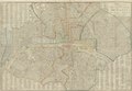
 Plan routier de la ville et fauxbourgs de Paris, 1827 - Stanford Libraries.jpg 13,163 × 9,105; 21.49 MB
-
 Plan routier de la ville et fauxbourgs de Paris, 1827 - Stanford Libraries.tif 13,163 × 9,105; 114.32 MB
-
 Plan-vélo des environs de Paris - btv1b530277912.jpg 9,716 × 6,994; 14.3 MB


_(14780969061).jpg)


.jpg)