Category:Old maps of the Isle of Bute
Jump to navigation
Jump to search
Media in category "Old maps of the Isle of Bute"
The following 17 files are in this category, out of 17 total.
-
 111 of 'The Isle of Bute in the Olden Time. With illustrations, etc' (11223927184).jpg 2,608 × 1,753; 394 KB
-

-
 132 of 'The Isle of Bute in the Olden Time. With illustrations, etc' (11223763464).jpg 1,913 × 2,610; 641 KB
-
 "Buthe Insula vulgo The Yle of Boot - Auct. Tim Pont" (22246521752).jpg 3,894 × 3,108; 1.9 MB
-
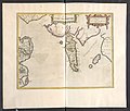 Buthe Insula - Atlas Maior, vol 6, map 24 - Joan Blaeu, 1667 - BL 114.h(star).6.(24).jpg 4,000 × 3,403; 1.78 MB
-
 Admiralty Chart No 1906 Kyles of Bute and Inchmarnock Water, Published 1956.jpg 11,072 × 16,166; 18.63 MB
-
 Admiralty Chart No 2131 Scotland west coast Firth of Clyde, Published 1891.jpg 10,896 × 11,809; 23.16 MB
-
 Admiralty Chart No 2159 Firth of Clyde, Published 1869.jpg 11,193 × 19,484; 22.08 MB
-
 Admiralty Chart No 3527 Rothesay Bay and Approaches, Published 1905.jpg 12,083 × 8,270; 32.69 MB
-

-
 Blaeu - Atlas of Scotland 1654 - BUTHE INSULA - The Isle of Bute.jpg 6,175 × 4,692; 5.11 MB
-
 Ordnance Survey One-Inch Sheet 59 Firth of Clyde, Published 1956.jpg 8,619 × 10,676; 9.7 MB
-
 Ordnance Survey One-Inch Sheet 59 Firth of Clyde, Published 1965.jpg 8,314 × 9,866; 11.22 MB
-
 Ordnance Survey One-Inch Sheet 71 Island of Bute, Published 1925.jpg 12,190 × 11,123; 13.44 MB
-
 Ordnance Survey One-Inch Sheet 71 Island of Bute, Published 1945.jpg 12,194 × 11,215; 14.01 MB
-
 Ordnance Survey One-Inch Tourist Map of Rothesay and Firth of Clyde, Published 1920.jpg 8,604 × 11,534; 24.19 MB
-
 Ordnance Survey Quarter-inch sheet 2 Scotland south-west, published 1946.jpg 15,110 × 10,911; 17.48 MB
.jpg)
.jpg)
.jpg)
.jpg)
.6.(24).jpg)


.png)


