Category:Old maps of the Isle of Arran
Jump to navigation
Jump to search
Media in category "Old maps of the Isle of Arran"
The following 19 files are in this category, out of 19 total.
-
 Blaeu - Atlas of Scotland 1654 - ARANIA - The Isle of Arran.jpg 6,184 × 4,667; 5.18 MB
-

-
 Arania Insula… - Atlas Maior, vol 6, map 23 - Joan Blaeu, 1667 - BL 114.h(star).6.(23).jpg 4,000 × 3,360; 1.74 MB
-

-

-

-
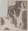
 Admiralty Chart No 1966 Scotland West Coast sheet II. Frith of Clyde &c., Surveyed 1846.jpg 10,196 × 8,078; 19.57 MB
-
 Admiralty Chart No 2131 Scotland west coast Firth of Clyde, Published 1891.jpg 10,896 × 11,809; 23.16 MB
-
 Admiralty Chart No 2159 Firth of Clyde, Published 1869.jpg 11,193 × 19,484; 22.08 MB
-
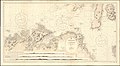 Admiralty Chart No 46 Ailsa Craig to Bloody Foreland, Published 1861.jpg 20,202 × 11,078; 58.98 MB
-
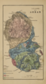 Bryce Arran Geological Map, published 1859.tif 2,800 × 5,092; 9.49 MB
-
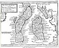
 BUTESHIRE map.jpg 1,985 × 3,051; 1.24 MB
-

-
 Ordnance Survey One-Inch Sheet 59 Firth of Clyde, Published 1956.jpg 8,619 × 10,676; 9.7 MB
-
 Ordnance Survey One-Inch Sheet 59 Firth of Clyde, Published 1965.jpg 8,314 × 9,866; 11.22 MB
-
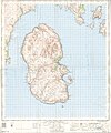
 Ordnance Survey One-Inch Sheet 66 Arran, Published 1956 2.jpg 10,733 × 10,661; 13.95 MB
-
 Ordnance Survey One-Inch Sheet 66 Arran, Published 1956.jpg 8,256 × 9,888; 7.08 MB
-
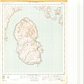
 Ordnance Survey One-Inch Sheet 77 Island of Arran, Published 1945.jpg 12,272 × 11,611; 11.75 MB
-
 Shire of Bute.jpg 5,024 × 4,129; 1.63 MB

.jpg)
.6.(23).jpg)
.jpg)
%27_(11052953596).jpg)
%27_(11298063703).jpg)


.jpg)


