Category:Old maps of Vancouver Island
Jump to navigation
Jump to search
Media in category "Old maps of Vancouver Island"
The following 21 files are in this category, out of 21 total.
-
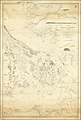
 (Map showing coast of northwestern portion of Vancouver Island). LOC 91683690.jpg 5,290 × 6,643; 3.27 MB
-

-

-

-

-

-

-

-

-

-

-
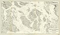
 Admiralty Chart No 2689 Haro and Rosario Straits Surveyed By Captn. G.H. Richards, Published 1859.jpg 16,075 × 23,895; 66.24 MB
-
-

-
 Bancroft's Works History of the Northwest Coast vol 1 (1884) (14577962788).jpg 2,493 × 3,351; 2.15 MB
-
-
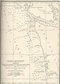
 FMIB 44345 Summer Fishing Grounds of Seattle Halibut Fleet.jpeg 791 × 855; 82 KB
-

-

-

-
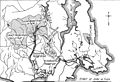 Sooke Water System 1915.jpg 1,834 × 1,249; 553 KB
._LOC_91683690.jpg)

.jpg)
.jpg)
.jpg)
.jpg)
.jpg)
_(1899)_(19995533784).jpg)
_(1899)_(19997206773).jpg)
_(1899)_(20430124030).jpg)


_Surveyed_by_Captn._G.H._Richards_and_the_Officers_of_the_H.M.S._Plumper_1858,_Published_1864,_Corrections_to_1865.jpg)
_(14577962788).jpg)


_(With_a_map.)%27_(11248039595).jpg)
_(With_a_map.)%27_(16590217435).jpg)

