Category:Maps of Vancouver Island
Jump to navigation
Jump to search
Wikimedia category | |||||
| Upload media | |||||
| Instance of | |||||
|---|---|---|---|---|---|
| Category combines topics | |||||
| Vancouver Island | |||||
island of British Columbia, Canada    | |||||
| Instance of | |||||
| Location | British Columbia, Canada | ||||
| Located in or next to body of water | |||||
| Time of discovery or invention |
| ||||
| Width |
| ||||
| Length |
| ||||
| Highest point |
| ||||
| Population |
| ||||
| Area |
| ||||
| Different from | |||||
 | |||||
Subcategories
This category has only the following subcategory.
!
- Old maps of Vancouver Island (21 F)
Media in category "Maps of Vancouver Island"
The following 58 files are in this category, out of 58 total.
-
 Admiralty Chart Catalogue 1967 Page 096 Index Q2.jpg 8,576 × 6,865; 8.03 MB
-
 Admiralty Chart No 2870 Discovery Passage to Bute Inlet, Published 1959.jpg 10,995 × 16,233; 71.74 MB
-
 Admiralty Chart No 569 Esperanza to Clayoquot, Published 1865, New Edition 1918.jpg 10,988 × 16,168; 60.53 MB
-
 Admiralty Chart No 582 Cape Caution to Quatsino Sound, Published 1959.jpg 16,249 × 11,103; 47.33 MB
-
 Bamberton LNG Proposed Pipeline.png 1,108 × 778; 831 KB
-
 Bamberton Location.png 1,183 × 835; 1.27 MB
-
 BChighway17.svg 1,142 × 817; 58 KB
-
 Bensonmap.jpg 1,080 × 1,080; 257 KB
-
 Biomed Area Map.png 221 × 192; 31 KB
-
 Canada Vancouver Island location map.svg 724 × 685; 507 KB
-
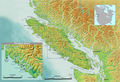
 Canada Vancouver Island relief map.jpg 3,017 × 2,851; 1.74 MB
-
 Carte baie Nootka.svg 566 × 725; 85 KB
-
 Carte ile de Vancouver.png 1,500 × 768; 1.21 MB
-
 Carte localisation baie et île Nootka.png 1,024 × 524; 616 KB
-
 Carte relief baie Nootka.png 542 × 697; 583 KB
-
 Courtenay--Alberni2019.svg 1,052 × 744; 7.52 MB
-
 Gulf Islands map 2 without border.png 801 × 871; 582 KB
-
 Gulf Islands map.png 770 × 669; 288 KB
-
 HO -1455, Waters between Vancouver Island and the Mainland - NARA - 84785958.jpg 24,493 × 19,168; 19.54 MB
-
 Inside Passage map.png 729 × 723; 303 KB
-
 Juan de Fuca unmarked without border ja.png 604 × 411; 499 KB
-
 Juan de Fuca unmarked without border.png 604 × 411; 500 KB
-
 Juan de Fuca unmarked.png 604 × 411; 514 KB
-
 Map Clayoquot Sound.png 628 × 440; 200 KB
-
 Map of Douglas Creek.svg 543 × 540; 6.11 MB
-
 Map of Nootka Island.png 569 × 540; 38 KB
-
 Muster-demis.gif 187 × 121; 21 KB
-
 Nanaimo—Alberni.png 370 × 507; 17 KB
-
 Pacific Rim National Park map, 1989 - 1 70,000.jpg 6,193 × 6,469; 8.15 MB
-
 Pacific Rim National Park.png 1,757 × 1,196; 4.12 MB
-
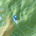 Peak Lake location.jpg 248 × 251; 14 KB
-
 Penelakut.png 1,814 × 1,196; 4.06 MB
-
 Regions of Vancouver Island, BC.png 6,474 × 4,012; 548 KB
-
 Siletzia.png 449 × 616; 58 KB
-
 Trail map and accidental selfie (8665836660).jpg 724 × 1,024; 449 KB
-
 Vancouver clayoquot sound de.png 1,757 × 1,196; 4.04 MB
-
 Vancouver de.png 1,666 × 1,196; 4.02 MB
-
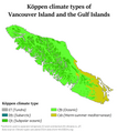 Vancouver Gulf Köppen.png 5,400 × 6,031; 315 KB
-
 Vancouver Gulf Köppen.svg 810 × 905; 577 KB
-
 Vancouver Island 40th Canadian Parliament riding map.png 370 × 507; 19 KB
-
 Vancouver Island colony.svg 2,419 × 1,960; 2.12 MB
-
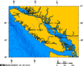
 Vancouver Island contour map.png 640 × 642; 196 KB
-
 Vancouver Island Map-fr.svg 1,249 × 862; 5.14 MB
-
 Vancouver Island South.png 1,757 × 1,196; 4.08 MB
-
 Vancouver Island, with Lasqueti Island highlighted.png 1,666 × 1,196; 3.82 MB
-
 Vancouver Island-relief CowichanRiver.png 578 × 600; 644 KB
-
 Vancouver Island-relief SquamishRiver.png 578 × 600; 643 KB
-
 Vancouver Island-relief.png 644 × 668; 782 KB
-
 Vancouver-island-lambert-azimuthal-without-border.png 514 × 411; 18 KB
-
 Vancouver-island-lambert-azimuthal.png 514 × 411; 13 KB
-
 Vancouver-island-relief.jpg 866 × 673; 154 KB
-
 Vancouver01.png 1,666 × 1,196; 4 MB
-
 Vi04.PNG 370 × 507; 19 KB
-
 Vicpc.PNG 370 × 507; 19 KB
-
 Vigpc.PNG 370 × 507; 19 KB
-
 VIHJL Team Locations.svg 375 × 400; 159 KB
-
 Vilpc.PNG 370 × 507; 19 KB
-
 Vindp.PNG 370 × 507; 19 KB


.jpg)


