Category:Old maps of Szczecin
Jump to navigation
Jump to search
Subcategories
This category has the following 2 subcategories, out of 2 total.
1
- Gates (Szczecin XVI century) (7 F)
Media in category "Old maps of Szczecin"
The following 39 files are in this category, out of 39 total.
-
 1042 of 'Neumanns Orts-Lexikon des Deutschen Reichs' (11225140426).jpg 2,720 × 1,756; 1.39 MB
-
 1043 of 'Neumanns Orts-Lexikon des Deutschen Reichs' (11228961663).jpg 2,720 × 1,756; 1.3 MB
-
 Stettin, Poland (1600) lower left.jpg 800 × 600; 130 KB
-
 Stettin, Poland (1600) lower right.jpg 800 × 600; 121 KB
-
 Stettin, Poland (1600) upper left.jpg 800 × 600; 132 KB
-
 Stettin, Poland (1600) upper right.jpg 800 × 600; 131 KB
-
 Stettin, Poland (1600).jpg 800 × 600; 111 KB
-
 Stettinum Merian.png 1,541 × 975; 807 KB
-
 Bethanien 1919 01.jpg 2,086 × 2,296; 1.31 MB
-
 Brockhaus' Konversations-Lexikon (1892) (14804339843).jpg 1,648 × 2,452; 603 KB
-
 Bundesarchiv Bild 196-02553, Stettin.jpg 791 × 800; 141 KB
-
 Bundesarchiv Bild 196-02653, Podejuch.jpg 800 × 792; 129 KB
-
 Bundesarchiv Bild 196-02654, Altdamm.jpg 783 × 800; 117 KB
-
 DammscherSee - Stocznie.svg 1,058 × 993; 435 KB
-
 DammscherSee.jpg 1,058 × 993; 302 KB
-
 Kungsboken-karta-stettin-2.jpg 14,201 × 12,885; 11.65 MB
-
 Mapa przedwojenna Pomorza (Stettin).jpg 1,323 × 1,696; 1.54 MB
-
 Mosty nad Regaliczką - plan.png 452 × 427; 363 KB
-
 Plan över Stettin, stad och fästning 1739 - Skoklosters slott - 98085.tif 5,320 × 3,580; 54.51 MB
-
 Plattegrond van Stettin, 1693, RP-P-OB-83.033A-50.jpg 5,740 × 4,592; 3.58 MB
-

-
 Stadtplan von Stettin 1939.jpg 3,117 × 3,310; 10.45 MB
-
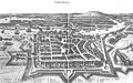
 Stetinum 1641.jpg 720 × 573; 166 KB
-
 Stettin (Doppelseitige Farbkarte).jpg 800 × 1,101; 223 KB
-
 Stettin im Jahre 1693.jpg 4,437 × 3,649; 5.09 MB
-
 Stettin merian.JPG 1,632 × 1,024; 919 KB
-
 Szczecin - Stettin - Map (1879) - 2.svg 1,388 × 1,200; 871 KB
-
 Szczecin - Stettin - Map (1879) - high resolution.jpg 5,231 × 4,522; 12.01 MB
-
 Szczecin Lubinus.PNG 1,592 × 1,012; 181 KB
-
 WIG Mapa Operacyjna Polski - 42 Stettin (Szczecin) 1938.jpg 6,046 × 5,647; 14.24 MB
-

-
 Delineatio obsidionis urbis Stetini. non ante 1696 (40974819).jpg 10,470 × 8,771; 19.06 MB
-
 Plan miasta Szczecina 1949 (102189196).jpg 15,028 × 19,243; 37.88 MB
-
 Plan miasta Szczecina. 1947 (65879999).jpg 14,898 × 17,474; 49.31 MB
-
 Plan miasta Szczecina. ca 1945 (69019209).jpg 14,181 × 19,635; 48.16 MB
-
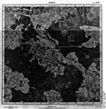
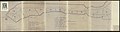 Rejony portu Szczecina. 1948 (65996704).jpg 27,603 × 7,470; 29.91 MB
-

-
 Stettin. 1890 (69264996).jpg 5,858 × 7,274; 8.33 MB
-

.jpg)
.jpg)
_lower_left.jpg)
_lower_right.jpg)
_upper_left.jpg)
_upper_right.jpg)
.jpg)


_(14804339843).jpg)


.jpg)


_Les_Forces_de_l%27Europe,_Asie,_Afrique_et_Amerique,_ou_description_des_principales_villes_avec_leurs_fortifications.,_RP-P-OB-83.034-144.jpg)


.jpg)


_-_2.svg)
_-_high_resolution.jpg)

_1938.jpg)
.jpg)
.jpg)
.jpg)
.jpg)
.jpg)
.jpg)
.jpg)
.jpg)
.jpg)