Category:Old maps of Somerset County, Pennsylvania
Jump to navigation
Jump to search
Counties of Pennsylvania : Adams · Allegheny · Armstrong · Beaver · Bedford · Berks · Blair · Bradford · Bucks · Butler · Cambria · Cameron · Carbon · Centre · Chester · Clarion · Clearfield · Clinton · Columbia · Crawford · Cumberland · Dauphin · Delaware · Elk · Erie · Fayette · Franklin · Fulton · Greene · Huntingdon · Indiana · Jefferson · Juniata · Lackawanna · Lancaster · Lawrence · Lebanon · Lehigh · Luzerne · Lycoming · McKean · Mercer · Mifflin · Monroe · Montgomery · Montour · Northampton · Northumberland · Perry · Philadelphia · Pike · Potter · Schuylkill · Snyder · Somerset · Sullivan · Susquehanna · Tioga · Union · Venango · Warren · Washington · Wayne · Westmoreland · Wyoming · York
Subcategories
This category has the following 6 subcategories, out of 6 total.
S
Media in category "Old maps of Somerset County, Pennsylvania"
The following 57 files are in this category, out of 57 total.
-
 Map of Somerset County LOC 2012592182.jpg 6,143 × 5,128; 4.53 MB
-
 Map of Somerset County LOC 2012592182.tif 6,143 × 5,128; 90.13 MB
-
 Somerset Co., Penn'a (13961080926).jpg 1,918 × 2,000; 4.5 MB
-
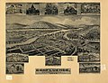
 Bird's eye view of Windber, Pa. Somerset County 1900. LOC 73693146.jpg 9,040 × 5,576; 9.31 MB
-
 Bird's eye view of Windber, Pa. Somerset County 1900. LOC 73693146.tif 9,040 × 5,576; 144.22 MB
-
 Somerset, Pennsylvania 1900. LOC 75696540.jpg 7,464 × 5,864; 10.75 MB
-
 Somerset, Pennsylvania 1900. LOC 75696540.tif 7,464 × 5,864; 125.22 MB
-
 Confluence, Pennsylvania 1905 LOC gm71005345.jpg 6,848 × 5,264; 7.54 MB
-
 Confluence, Pennsylvania 1905 LOC gm71005345.tif 6,848 × 5,264; 103.13 MB
-
 Txu-pclmaps-topo-pa-somerset-1913.jpg 3,943 × 4,770; 7.65 MB
-

-

-

-

-

-

-

-

-

-

-

-

-

-

-

-

-

-

-

-

-

-

-

-

-

-

-

-

-

-

-

-

-

-

-

-

-

-

-

-

-

-

-

-

-

-

-


.jpg)


.jpg)
.jpg)
.jpg)
.jpg)
.jpg)
.jpg)
.jpg)
.jpg)

.jpg)
.jpg)
.jpg)
.jpg)
.jpg)
.jpg)


.jpg)
.jpg)


.jpg)
.jpg)
.jpg)
.jpg)
.jpg)

.jpg)
.jpg)
.jpg)
.jpg)
.jpg)
.jpg)
.jpg)
.jpg)
.jpg)
.jpg)