Category:Old geological maps of New Zealand
Jump to navigation
Jump to search
Subcategories
This category has the following 2 subcategories, out of 2 total.
Media in category "Old geological maps of New Zealand"
The following 15 files are in this category, out of 15 total.
-
 EB1911 New Zealand - geological map.jpg 864 × 1,250; 210 KB
-
 FMIB 50791 Geological Map of Campbell Island.jpeg 1,218 × 1,323; 228 KB
-
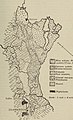
 FMIB 50811 Geological Sketch Map of Southern Half of Auckland Islands.jpeg 1,253 × 1,665; 286 KB
-
 Geological sketch map of the Chatham Islands.jpg 1,056 × 1,737; 180 KB
-
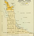
 The geology of the Coromandel subdivision, Hauraki, Auckland (1907) (14591951710).jpg 2,910 × 3,214; 1.26 MB
-
 The geology of the Coromandel subdivision, Hauraki, Auckland (1907) (14592026988).jpg 3,430 × 3,452; 2.25 MB
-
 The geology of the Coromandel subdivision, Hauraki, Auckland (1907) (14755670146).jpg 2,064 × 3,006; 496 KB
-
 The geology of the Coromandel subdivision, Hauraki, Auckland (1907) (14776321144).jpg 2,430 × 2,612; 464 KB
-
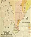
 The geology of the New Plymouth subdivision, Taranaki division (1912) (14589487880).jpg 2,056 × 3,008; 466 KB
-

-
-
 Transactions (1871) (14596377709).jpg 1,206 × 1,844; 154 KB
-
 Transactions of the Royal Society of New Zealand (1911) (14758898376).jpg 1,864 × 3,076; 554 KB
-
 Transactions of the Royal Society of New Zealand (1920) (14578410949).jpg 2,428 × 3,236; 848 KB
-
 Transactions of the Royal Society of New Zealand (1920) (14761904291).jpg 2,332 × 3,768; 880 KB


_(14591951710).jpg)
_(14592026988).jpg)
_(14755670146).jpg)
_(14776321144).jpg)
_(14589487880).jpg)
_(1918)_(14598027478).jpg)
_(1918)_(14784697365).jpg)
_(14596377709).jpg)
_(14758898376).jpg)
_(14578410949).jpg)
_(14761904291).jpg)