Category:Official topographic maps of Sucre (state)
Jump to navigation
Jump to search
Federal territory: Capital District ·
Media in category "Official topographic maps of Sucre (state)"
The following 14 files are in this category, out of 14 total.
-
 Hoja 7346 - SANTA FE, MOCHIMA, TURIMIQUIRE, BERGANTÍN - DCN 1969.jpg 8,268 × 6,593; 67.09 MB
-
 Hoja 7347 - CUMANÁ, ARAYA - DCN 1964.jpg 8,344 × 6,612; 55.68 MB
-
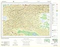
 Hoja 7446 - CUMANACOA, CARIPE, GUANAGUANA, EL GUÁCHARO - DCN 1964.jpg 8,356 × 6,601; 70.77 MB
-
 Hoja 7447 - CARIACO, MARIGÜITAR - DCN 1970.jpg 8,268 × 6,600; 60.24 MB
-
 Hoja 7448 - MARGARITA SURESTE - DCN 1962.jpg 8,268 × 6,594; 52.08 MB
-
 Hoja 7448 - MARGARITA SURESTE - DCN 1979.jpg 8,473 × 6,591; 71.5 MB
-
 Hoja 7546 - CARIPITO - DCN 1969.jpg 8,348 × 6,605; 66.69 MB
-
 Hoja 7547 - CASANAY, CARÚPANO, EL PILAR - DCN 1969.jpg 8,332 × 6,613; 72.82 MB
-
 Hoja 7548 - CARÚPANO, RÍO CARIBE - DCN 1966.jpg 8,336 × 6,605; 66.3 MB
-
 Hoja 7548 - CARÚPANO, RÍO CARIBE - DCN 1972.jpg 8,360 × 6,603; 52.85 MB
-
 Hoja 7646 - GUARIQUÉN, GUANOCO - DCN 1981.jpg 4,264 × 3,310; 19.33 MB
-
 Hoja 7647 - IRAPA, YAGUARAPARO - DCN 1975.jpg 8,376 × 6,653; 55.56 MB
-
 Hoja 7648 - SAN JUAN DE LAS GALDONAS - DCN 1974.jpg 8,336 × 6,611; 57.68 MB
-
 Hojas 7847 y 7848 - MACURO, GOLFO DE PARIA, TRINIDAD - DCN 1974.jpg 8,344 × 6,612; 59.18 MB


