Category:Nehantic Trail
Jump to navigation
Jump to search
 | |||||
| Upload media | |||||
| Instance of | |||||
|---|---|---|---|---|---|
| Location | Connecticut | ||||
 | |||||
Media in category "Nehantic Trail"
The following 19 files are in this category, out of 19 total.
-
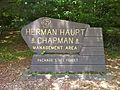 Nehantic Trail - Herman Haupt Chapman Management Area sign.jpg 2,592 × 1,936; 2.22 MB
-
 Nehantic Trail - Mount Misery National Geodetic Survey marker.jpg 1,936 × 2,592; 2.62 MB
-
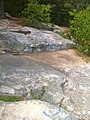 Nehantic Trail - Mount Misery summit.jpg 1,936 × 2,592; 2.28 MB
-
 Nehantic Trail - Rhododendron Sanctuary side trail entrance.jpg 1,936 × 2,592; 3.06 MB
-
 Nehantic Trail - Rhododendron Sanctuary Trail planked wooden boardwalk section.jpg 1,936 × 2,592; 2.94 MB
-
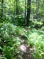
 Nehantic Trail - Rhododendron Sanctuary Trail.jpg 2,592 × 1,936; 2.83 MB
-
 Nehantic Trail - Rhododentron Sanctuary Trail entrance sign.jpg 2,592 × 1,936; 2.4 MB
-
 Nehantic Trail - View from Mount Misery.jpg 2,592 × 1,936; 2.61 MB
-
 Nehantic Trail and Pachaug Trail eastern fork split.jpg 1,936 × 2,592; 3.1 MB
-
 Nehantic Trail and Pachaug Trail western fork split.jpg 2,592 × 1,936; 2.68 MB
-
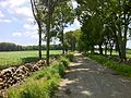
 Nehantic Trail off Green Falls Rd in Pachaug State Forest.jpg 1,936 × 2,592; 2.67 MB
-
 Nehantic Trail off Green Falls Rd near southeastern trailhead.jpg 1,936 × 2,592; 2.85 MB
-
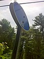 Nehantic Trail sign at CT State Route 138 Crossing.jpg 1,936 × 2,592; 1.84 MB
-
 Nehantic Trail sign at CT State Route 49 Crossing.jpg 1,936 × 2,592; 2.37 MB
-
 Nehantic Trail sign at Shetucket Turnpike Crossing.jpg 1,936 × 2,592; 2.13 MB
-
 Nehantic Trail sign on Green Falls Rd at southeastern trailhead.jpg 1,936 × 2,592; 3.1 MB
-
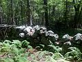
 Pachaug-Nehantic Crossover - stone wall ruins, Voluntown, CT.jpg 2,592 × 1,936; 2.76 MB
-
 Quinebaug-Nehantic Crossover Trail's Lee Road section.jpg 2,592 × 1,936; 2.55 MB
-
 Stone fence hear Nehantic Trail & Nehantic-Pachaug Crossover Trail intersection.jpg 2,592 × 1,936; 2.57 MB


