Category:Media from the National Library of Finland
Jump to navigation
Jump to search
National Library of Finland releases all files with Creative Commons CC0 waiver. View the license page.
Subcategories
This category has the following 2 subcategories, out of 2 total.
M
N
Media in category "Media from the National Library of Finland"
The following 41 files are in this category, out of 41 total.
-
 Belägenheten af Helsingfors och Sveaborg 1808.jpeg 5,424 × 4,456; 2.53 MB
-
 Establishment of the Finnish Defence Forces with day order no 1.jpg 2,439 × 3,123; 3.17 MB
-
 Gamble Helsingefors 1900.jpeg 5,520 × 4,248; 2.11 MB
-

-
 Helsingfors med omgifningar 1845.jpeg 8,336 × 6,480; 5.48 MB
-
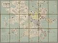
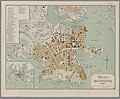
 Helsingin asemakaava 1909.jpeg 5,288 × 6,184; 4.53 MB
-
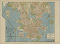
 Helsingin kartta 1932 2.jpeg 4,632 × 5,968; 3.11 MB
-
 Helsingin kartta 1932.jpeg 5,920 × 4,648; 3.3 MB
-
 Helsingin matkailijakartta 1940 2.jpg 7,232 × 7,560; 38.11 MB
-
 Helsingin matkailijakartta 1940.jpg 8,320 × 5,088; 29.71 MB
-
 Helsingin matkailijakartta 1949.jpg 8,320 × 5,088; 30.02 MB
-
 Helsingin raitiotiekartta 1 1932.jpeg 6,440 × 7,304; 4.76 MB
-
 Helsinki kartta 1696.jpeg 5,608 × 4,248; 1.99 MB
-
 Helsinki kartta ja luettelo kaduista ja nähtävyyksistä 1924.jpeg 5,224 × 8,784; 7.39 MB
-
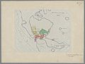
 Helsinki ympäristöineen 1929 2.jpeg 1,720 × 2,944; 453 KB
-
 Helsinki ympäristöineen 1929.jpeg 10,640 × 5,480; 8.15 MB
-

-
 Italine - lyriska skaldeförsök.pdf 693 × 1,041, 136 pages; 8.5 MB
-
Kaipaava RAI-HMVX3270-01-2-002.mp3 3 min 12 s; 1.46 MB
-
 Karta öfver Helsingfors 1860.jpeg 5,384 × 5,160; 3.58 MB
-
 Karta öfver Helsingfors 1866.jpeg 8,848 × 6,512; 6.85 MB
-

-
 Kopiokirja, Kansalliskirjasto, Helsinki.jpg 3,121 × 1,986; 4.11 MB
-
 Map of Helsinki-Helsingfors 1935 2.jpeg 1,288 × 2,208; 257 KB
-
 Map of Helsinki-Helsingfors 1935.jpeg 4,728 × 4,288; 3.06 MB
-
 Pharus-asemakaava Helsinki.jpg 4,744 × 6,304; 21.6 MB
-
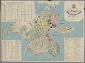 Plan af Helsingfors 1863.jpeg 6,760 × 5,088; 4 MB
-
 Plan af Helsingfors 1876.jpeg 9,016 × 7,184; 7.54 MB
-
 Plan af Helsingfors 1893.jpeg 5,472 × 4,528; 3.19 MB
-

-

-
 Plan af Helsingfors jemte omgifning 1880.jpeg 7,088 × 3,976; 3.37 MB
-
 Plan af Helsingfors år 1859.jpeg 4,328 × 3,720; 2.33 MB
-
 Plankarta öfver Helsingfors stad 1916 A1 1.jpeg 11,072 × 6,288; 9.03 MB
-
 Plankarta öfver Helsingfors stad 1916 A1 2.jpeg 11,072 × 6,288; 9.77 MB
-
 Plankarta öfver Helsingfors stad 1916 A1.jpeg 11,017 × 8,118; 12.03 MB
-
 Plankarta öfver Helsingfors stad 1916 A2 1.jpeg 11,072 × 6,288; 10.22 MB
-
 Plankarta öfver Helsingfors stad 1916 A2 2.jpeg 11,064 × 6,288; 9.78 MB
-
 Plankarta öfver Helsingfors stad 1916 A2.jpeg 10,995 × 8,111; 12.86 MB
-
RAI-HMVZ212 02.mp3 3 min 49 s; 8.73 MB
-