Category:May 2006 in County Down
Jump to navigation
Jump to search
English: Images taken in County Down, Northern Ireland in this month of 2006 (not the date of the upload).
| Jan | Feb | Mar | Apr | May | Jun | Jul | Aug | Sep | Oct | Nov | Dec | ||
| ← | 18 | 25 | 49 | 17 | 43 | 71 | 74 | 97 | 51 | 64 | 35 | 36 | → |
|---|
Media in category "May 2006 in County Down"
The following 43 files are in this category, out of 43 total.
-
 A Passing Steam train - geograph.org.uk - 350110.jpg 640 × 426; 83 KB
-

-
 Church, Drumbanagher - geograph.org.uk - 175537.jpg 640 × 426; 135 KB
-
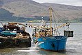
 Departure of the "Maria Lena" - geograph.org.uk - 189535.jpg 640 × 426; 151 KB
-
 Disused Newry canal, Scarva (1) - geograph.org.uk - 175517.jpg 640 × 426; 197 KB
-
 Down Cathedral - geograph.org.uk - 172263.jpg 640 × 426; 145 KB
-
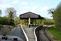 Downpatrick Loop Platform - geograph.org.uk - 350087.jpg 640 × 426; 117 KB
-
 Drumlin country (2) - geograph.org.uk - 171282.jpg 640 × 426; 149 KB
-
 Drumlin country (3) - geograph.org.uk - 171700.jpg 640 × 426; 170 KB
-
 Drumlin country (4) - geograph.org.uk - 172005.jpg 640 × 426; 162 KB
-
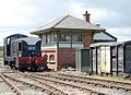 E421 shunting at Downpatrick - geograph.org.uk - 325236.jpg 640 × 465; 134 KB
-
 English Street (south side), Downpatrick - geograph.org.uk - 172280.jpg 640 × 426; 135 KB
-
 Fishermens memorial, Portavogie harbour - geograph.org.uk - 172290.jpg 640 × 426; 136 KB
-
 Flood gates Quoile River - geograph.org.uk - 171702.jpg 640 × 426; 142 KB
-
 Grey Abbey (314914).jpg 640 × 426; 162 KB
-
 Grey Abbey Co Down - geograph.org.uk - 1442487.jpg 640 × 427; 68 KB
-
 Houses at Comber Street, Saintfield - geograph.org.uk - 163402.jpg 640 × 426; 151 KB
-
 Industrial Estate situated at Conlig. - geograph.org.uk - 228443.jpg 640 × 480; 40 KB
-
 Killyleagh Castle1.jpg 640 × 480; 255 KB
-
 Lifeboathouse, Bangor - geograph.org.uk - 190866.jpg 640 × 426; 136 KB
-

-
 Milepost, Newry canal, Scarva - geograph.org.uk - 175531.jpg 640 × 426; 194 KB
-
 Milestone, Hillsborough Fort - geograph.org.uk - 171293.jpg 640 × 426; 182 KB
-
 Mussel dredger at Rostrevor Quay - geograph.org.uk - 174331.jpg 640 × 426; 151 KB
-
 Newcastle lifeboat - geograph.org.uk - 174893.jpg 640 × 426; 156 KB
-

-
 Old lifeboathouse, Newcastle - geograph.org.uk - 174892.jpg 640 × 426; 150 KB
-
 Old railway bridge, Banbridge (1) - geograph.org.uk - 175483.jpg 640 × 426; 183 KB
-
 Old railway bridge, Millmount, Banbridge - geograph.org.uk - 175507.jpg 640 × 426; 204 KB
-
 Old railway, Banbridge - geograph.org.uk - 175493.jpg 640 × 426; 192 KB
-

-
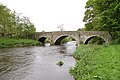
 Quoile Bridge near Downpatrick - geograph.org.uk - 171701.jpg 640 × 426; 144 KB
-
 Ringneill Road, Strangford Lough - geograph.org.uk - 166399.jpg 640 × 426; 140 KB
-
 River Bann near the Corbet - geograph.org.uk - 171976.jpg 640 × 426; 154 KB
-

-
 St Patrick's grave^ - geograph.org.uk - 172267.jpg 640 × 426; 164 KB
-
 St Saviour's, Greyabbey - geograph.org.uk - 178040.jpg 640 × 426; 149 KB
-
 The Long Hole, Bangor (1) - geograph.org.uk - 197826.jpg 640 × 426; 118 KB
-
 The Quay, Strangford - geograph.org.uk - 172285.jpg 640 × 426; 168 KB
-
 The war memorial, Ward Park, Bangor - geograph.org.uk - 174886.jpg 640 × 426; 116 KB
-
 Towpath, disused Newry canal, Scarva - geograph.org.uk - 175525.jpg 640 × 426; 164 KB
-

-
 Victoria locks, Newry ship canal - geograph.org.uk - 174515.jpg 640 × 426; 135 KB


_-_geograph.org.uk_-_175517.jpg)


_-_geograph.org.uk_-_171282.jpg)
_-_geograph.org.uk_-_171700.jpg)
_-_geograph.org.uk_-_172005.jpg)

,_Downpatrick_-_geograph.org.uk_-_172280.jpg)


.jpg)


_-_geograph.org.uk_-_175483.jpg)


_-_geograph.org.uk_-_161804.jpg)


_-_geograph.org.uk_-_197826.jpg)


