Category:Maps showing 1990
Jump to navigation
Jump to search
| ← 1990 1991 1992 1993 1994 1995 1996 1997 1998 1999→ |
English: Maps showing the year 1990 (i.e. history maps)
See also category: 1990 maps. and 1990s maps for more maps showing this year usually created not long after the given year.
See also category: 1990 maps. and 1990s maps for more maps showing this year usually created not long after the given year.
Subcategories
This category has only the following subcategory.
Media in category "Maps showing 1990"
The following 15 files are in this category, out of 15 total.
-
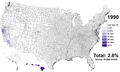 Asian Americans 1990 County.png 7,750 × 4,650; 8.64 MB
-
 Black Americans 1990 County.png 15,610 × 8,900; 19.01 MB
-
 BlankMap-World 1990.svg 1,340 × 680; 1.23 MB
-
 BlankMap-World-1990.png 1,425 × 625; 17 KB
-
 Death-rate-smoking,Africa,1990.svg 850 × 699; 146 KB
-
 Death-rate-smoking,Asia,1990.svg 850 × 699; 146 KB
-
 Death-rate-smoking,Europe,1990.svg 850 × 699; 153 KB
-
 Death-rate-smoking,North America,1990.svg 850 × 699; 144 KB
-
 Death-rate-smoking,Oceania,1990.svg 850 × 699; 144 KB
-
 Death-rate-smoking,South America,1990.svg 850 × 699; 145 KB
-
 Death-rate-smoking,World,1990.svg 850 × 699; 153 KB
-
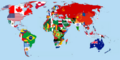 Flag-map of the world (1990).png 4,500 × 2,234; 566 KB
-
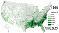
 Hispanic Americans 1990 County.png 9,470 × 5,635; 11.76 MB
-
 Non-Hispanic White Americans 1990 County.png 15,610 × 8,900; 16.78 MB
-
 White Americans 1990 County.png 15,610 × 8,900; 16.49 MB


.png)


