Category:Maps showing 1944
Jump to navigation
Jump to search
| ← 1940 1941 1942 1943 1944 1945 1946 1947 1948 1949→ |
English: Maps showing the year 1944 (i.e. history maps)
See also category: 1944 maps. and 1940s maps for more maps showing this year usually created not long after the given year.
See also category: 1944 maps. and 1940s maps for more maps showing this year usually created not long after the given year.
Media in category "Maps showing 1944"
The following 20 files are in this category, out of 20 total.
-
 Comprehensive Cartographia - South America 1944.png 1,579 × 2,160; 156 KB
-
Evolution of United States standard time zone boundaries.webm 29 s, 3,507 × 2,480; 4.58 MB
-
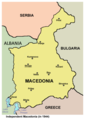
 Independent Macedonia 1944 EN.png 908 × 1,313; 30 KB
-
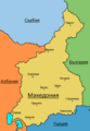
 Macedonia 1944 bg.png 320 × 449; 48 KB
-
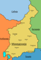
 Macedonia 1944 en2.png 320 × 449; 55 KB
-
 The settlement of the northern part of the Aukh district by Laks in 1944.svg 744 × 1,064; 477 KB
-
 World War II 1944 01.png 1,357 × 628; 33 KB
-
 World War II 1944 02.png 1,357 × 628; 34 KB
-
 World War II 1944 03.png 1,357 × 628; 33 KB
-
 World War II 1944 04.png 1,357 × 628; 34 KB
-
 World War II 1944 05.png 1,357 × 628; 33 KB
-
 World War II 1944 06.png 1,357 × 628; 33 KB
-
 World War II 1944 07.png 1,357 × 628; 33 KB
-
 World War II 1944 08.png 1,357 × 628; 33 KB
-
 World War II 1944 09.png 1,357 × 628; 34 KB
-
 World War II 1944 10.png 1,357 × 628; 33 KB
-
 World War II 1944 11.png 1,357 × 628; 33 KB
-
 World War II 1944 12.png 1,357 × 628; 33 KB
-
 Независима Държава Македония 1944.png 908 × 1,313; 29 KB
-
 Независна Држава Македониjа 1944.png 908 × 1,313; 29 KB


