Category:Maps of weather forecast and climate prediction
Jump to navigation
Jump to search
Subcategories
This category has the following 6 subcategories, out of 6 total.
Media in category "Maps of weather forecast and climate prediction"
The following 13 files are in this category, out of 13 total.
-
 2013-12-12 48h North Atlantic surface forecast.gif 1,728 × 1,100; 78 KB
-
 2013-12-22-05-32-UTC 48h North Atlantic surface forecast.gif 1,728 × 1,100; 84 KB
-
 Day1may3198.png 600 × 400; 13 KB
-
 Day1otlk 19980415 1200.png 600 × 400; 13 KB
-
 Day1otlk 19990504 0600 (1).png 600 × 400; 12 KB
-
 ECDM 20190121 TC DESMOND.pdf 1,625 × 1,125; 1.01 MB
-
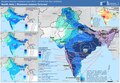 ECDM 20240610 Monsoon.pdf 1,625 × 1,125; 586 KB
-
 ECDM 20240626 Hurricane season forecast.pdf 1,625 × 1,125; 564 KB
-
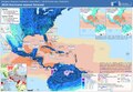
 Karte Nord- und Ostsee.png 800 × 854; 195 KB
-
 Klima kipp punkte.png 500 × 300; 125 KB
-
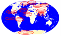
 Map of tropical cyclone affected areas.png 1,347 × 624; 94 KB
-
 UK shipping forecast zones.png 960 × 1,280; 257 KB
-
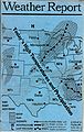 Weather Report.jpg 3,240 × 5,112; 4.11 MB


.png)


