Category:Maps of the Society Islands
Jump to navigation
Jump to search
Subcategories
This category has the following 10 subcategories, out of 10 total.
- Maps of Huahine (12 F)
- Maps of Mehetia (3 F)
- Maps of Tetiaroa (2 F)
!
- SVG maps of the Society Islands (19 F)
*
- Maps of Raiatea (15 F)
Media in category "Maps of the Society Islands"
The following 21 files are in this category, out of 21 total.
-

-
 1769 Cook Map of the Society Islands - Geographicus - SoecityIsland-cook-1769.jpg 4,000 × 2,708; 2.29 MB
-
 1780 Cook - Hogg Map of Tahiti ( Society Islands ) - Geographicus - Tahiti-hogg-1780.jpg 4,000 × 2,138; 912 KB
-
 PERKINS(1854) p246 MAP OF TAHITI ISLANDS.jpg 2,137 × 1,297; 1.11 MB
-

-
 Admiralty Chart Catalogue 1967 Page 091 Index P1.jpg 8,580 × 6,834; 7.72 MB
-
 Admiralty Chart No 1107 Plans in the Iles de la Societe, Published 1972.jpg 16,344 × 11,260; 29.98 MB
-
 All the Islands accountofvoyages 02hawk 0316.jpg 3,882 × 1,942; 371 KB
-
 Bora-Bora cropped from Admiralty Chart No 1107 Plans in the Iles de la Societe, Published 1972.jpg 7,861 × 10,136; 13.17 MB
-
 Carte des Isles de la Societé 1790.jpg 2,048 × 1,152; 265 KB
-
 Carte des isles de la Societé découvertes par le Lieutenant J. Cook, 1769 (19572710145).jpg 6,968 × 4,536; 4.46 MB
-
 Edward T. Perkins, Georgian and Society Islands, 1854.jpg 3,414 × 2,061; 2.21 MB
-

-
 Karta FP Societe isl.PNG 450 × 400; 6 KB
-
 LocationSocietyIslands.PNG 250 × 158; 5 KB
-
 Map-society-islands-hogg-1784.jpg 4,238 × 2,655; 9.57 MB
-
 Meyer‘s Zeitungsatlas 091 – Mittelamerika.jpg 7,267 × 6,238; 13.82 MB
-
 Societe isl Mehetia.PNG 447 × 211; 6 KB
-
 Societyislands.jpg 5,838 × 2,553; 489 KB
-
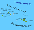 Tuulepealsed saared.png 450 × 400; 20 KB
-
 Windward Islands of Society Islands.jpg 2,534 × 1,504; 485 KB


_-_Geographicus_-_Tahiti-hogg-1780.jpg)
_p246_MAP_OF_TAHITI_ISLANDS.jpg)
%27_(11220361106).jpg)


.jpg)

_Deuxi%C3%A8me_%C3%A9dition%27_(16588900261).jpg)


