Category:Maps of the Kingdom of Saxony
Jump to navigation
Jump to search
Subcategories
This category has only the following subcategory.
K
- Königreich Sachsen 1895.jpg (26 F)
Media in category "Maps of the Kingdom of Saxony"
The following 19 files are in this category, out of 19 total.
-
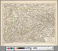
 Charte vom Königreiche Sachsen.jpg 9,619 × 6,892; 21.47 MB
-
 Charte von dem Koenigreich Sachsen.jpg 6,490 × 5,263; 8.22 MB
-
 Das Koenigreich Sachsen.jpg 6,601 × 5,510; 14.4 MB
-
 Deutsches R Sachsen.png 626 × 519; 56 KB
-
 Deutsches Reich (Karte) Sachsen.svg 650 × 545; 1.04 MB
-
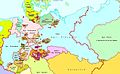
 Kingdom of Saxony (1812).svg 450 × 456; 611 KB
-
 Kingdom of Saxony 1812.svg 450 × 456; 607 KB
-
 Kingdom of Saxony 1815.svg 450 × 456; 812 KB
-
 Koenigreich Sachsen.jpg 6,397 × 5,551; 10.47 MB
-
 Königreich Sachsen.jpg 3,541 × 3,166; 5.3 MB
-
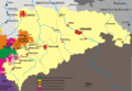
 Map-DB-Sachsen.svg 1,793 × 1,571; 1.67 MB
-
 Map-DR-Saxony.png 1,741 × 1,444; 65 KB
-
 Map-DR-Saxony.svg 2,621 × 2,224; 712 KB
-
 Map-saxony1900.png 3,653 × 2,538; 115 KB
-
 Sachsen-1809.jpg 1,314 × 827; 273 KB
-
 Sachsen-1820.jpg 1,328 × 822; 261 KB
-
 Sachsen-Karte-1809-1820.jpg 1,328 × 1,634; 573 KB
-
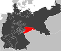
 Saxony in the German Reich (1871).svg 1,425 × 1,133; 1,014 KB
-
 Schulkarte des Koenigreichs Sachsen.jpg 8,058 × 5,977; 13.45 MB


_Sachsen.svg)
.svg)


.svg)
