Category:Maps of the Couto Misto
Jump to navigation
Jump to search
Media in category "Maps of the Couto Misto"
The following 14 files are in this category, out of 14 total.
-
 Coutomixto4.jpg 1,426 × 1,438; 176 KB
-
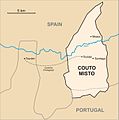
 Mapa do Couto Misto.png 1,073 × 967; 56 KB
-
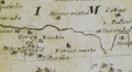 Couto Misto no mapa do bispado de Ourense de Cornide (1763).png 289 × 160; 75 KB
-
 Couto Misto no mapa do partido de Ourense de Juan Quintana (1807).jpg 1,498 × 1,419; 2.66 MB
-
 Carta topográfica do Julgado de Montalegre 1836 Fidencio Bourman (Couto misto).jpg 2,348 × 1,072; 920 KB
-
 Carta topográfica do Julgado de Montalegre 1836 Fidencio Bourman.jpg 4,776 × 3,361; 4.33 MB
-

-
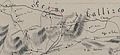
 Couto Misto na Carta Geométrica de Galiza (1845).jpg 1,663 × 1,032; 1.4 MB
-

-

-
 Couto Misto no mapa de José de Castro López (1863).jpg 2,095 × 2,070; 3.9 MB
-
 Tourém no mapa de José de Castro López (1863).jpg 2,248 × 2,188; 4.09 MB
-
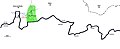
 Plano em que se sinalam as terras de pastos comuns do antigo Couto Misto (1898).jpg 3,100 × 2,185; 2.08 MB
-
 Coutomixto3.jpg 4,122 × 1,669; 336 KB


.png)
.jpg)
.jpg)

.jpg)
.jpg)


.jpg)
.jpg)
.jpg)