Category:Maps of the Battle of Königgrätz
Jump to navigation
Jump to search
Media in category "Maps of the Battle of Königgrätz"
The following 28 files are in this category, out of 28 total.
-

-

-

-

-

-

-
 Battle of Koniggratz hu.svg 1,407 × 989; 198 KB
-
 Battle of Koniggratz-es.svg 1,055 × 742; 268 KB
-
 Battle of Koniggratz-hu.svg 1,052 × 744; 83 KB
-
 Battle of Koniggratz.png 1,055 × 742; 202 KB
-
 Battle of Koniggratz.svg 1,052 × 744; 82 KB
-
-

-
 Image taken from page 106 of 'La Guerre de 1866' (11088861974).jpg 1,403 × 1,406; 162 KB
-
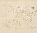 Image taken from page 237 of 'La Guerre de 1866' (11088796723).jpg 5,434 × 4,867; 3.33 MB
-
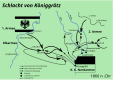
 Karte zur Schlacht bei Koeniggraetz (3. Juli 1866).jpg 729 × 736; 97 KB
-
 Koniggratz Map.jpg 3,842 × 2,593; 2.01 MB
-
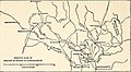
 Map03 large.jpg 2,339 × 1,654; 816 KB
-
 Meyers b9 s1018 b1.png 763 × 756; 271 KB
-
 Meyers b9 s1018.jpg 800 × 1,275; 335 KB
-
 Plan des Schlachtfeldes von Königgrätz - Nordwestliches Viertel.jpg 5,070 × 6,321; 9.21 MB
-
 Plan des Schlachtfeldes von Königgrätz - Nordöstliches Viertel.jpg 4,998 × 6,333; 9.31 MB
-
 Plan des Schlachtfeldes von Königgrätz - Südwestliches Viertel.jpg 5,061 × 6,275; 10 MB
-
 Plan des Schlachtfeldes von Königgrätz - Südöstliches Viertel.jpg 5,030 × 6,264; 7.78 MB
-

-

-
 Umgebungskarte der Schlacht bei Königgrätz.jpg 2,409 × 1,489; 1.32 MB
-

.jpg)
.jpg)
.jpg)
.jpg)
_E._H._(and)_W._v._Tr%C3%BCtzschler,_etc%27_(11085941726).jpg)
%27_(11092742984).jpg)


_(14781246272).jpg)
_(14799464973).jpg)
.jpg)
.jpg)
.jpg)


_(14776157961).jpg)
_(14778968842).jpg)

.jpg)