Category:Maps of rivers in the United Kingdom
Jump to navigation
Jump to search
Subcategories
This category has the following 16 subcategories, out of 16 total.
A
L
M
- Maps of River Clyde (23 F)
- Maps of River Forth (13 F)
- Maps of River Trent (30 F)
- Maps of River Tweed (27 F)
- Maps of River Yare (3 F)
- Maps of the River Itchen (7 F)
- Maps of the River Severn (33 F)
- Maps of the River Test (7 F)
O
- Maps of River Ouse, Yorkshire (12 F)
T
Media in category "Maps of rivers in the United Kingdom"
The following 72 files are in this category, out of 72 total.
-
 Harwich Harbour 1804.png 2,498 × 3,331; 1,012 KB
-
 Plan of the Creek at Holy Haven 1861 (transparent).png 976 × 1,253; 457 KB
-

-
 Abona rivers.gif 468 × 671; 14 KB
-
 Alaunos Rivers.gif 496 × 690; 19 KB
-
 Alnmouth Tithe Map 1843.png 954 × 1,494; 2.54 MB
-
 Beverley Brook and Pyl Brook.png 970 × 811; 436 KB
-
 CornwallMap2.png 700 × 526; 43 KB
-
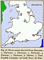 Dervent.jpg 250 × 336; 27 KB
-
 Eden rivers.gif 476 × 411; 11 KB
-
 FMIB 37998 Course of the River Severn from Gloucester to the Severn Tunnel.jpeg 792 × 1,587; 427 KB
-
 FoweyLooeRiversMapCornwallUK.gif 1,000 × 970; 49 KB
-
 Gb4dot rivers England.png 621 × 737; 190 KB
-
 Gb4dot rivers.svg 1,104 × 1,586; 482 KB
-

-
 Isca River names.gif 398 × 600; 30 KB
-
 Kent Rivers.svg 1,839 × 1,207; 125 KB
-
 Kent Town Rivers.svg 1,839 × 1,207; 121 KB
-
 Loch Lomond Map c 1800.jpg 3,616 × 5,072; 3.82 MB
-
 London natural watercourses.jpg 762 × 617; 54 KB
-
 Major.rivers.of.England.jpg 2,336 × 2,973; 959 KB
-
 Map of Inland Navigation I.jpg 2,465 × 1,980; 1.42 MB
-
 Map of Inland Navigation II.jpg 2,430 × 1,980; 1.33 MB
-
 Map of Inland Navigation III.jpg 2,430 × 1,980; 1.2 MB
-
 Map of Inland Navigation IV.jpg 2,465 × 1,980; 1.48 MB
-
 Map of Inland Navigation V.jpg 2,392 × 1,980; 1.28 MB
-
 Map of Inland Navigation VI.jpg 2,428 × 1,980; 1.38 MB
-
 Map of River Exe en.svg 600 × 600; 71 KB
-
 Map of the River Exe - Exe highlighted.svg 600 × 600; 82 KB
-
 Map of the River Wye (West Midlands and Wales, UK).jpeg 771 × 673; 127 KB
-
 MapOfRiverCamelCornwallUK.jpg 1,000 × 924; 106 KB
-
 MapRiversSoutheastCornwallUK.gif 600 × 630; 30 KB
-
 River Mole Map.png 447 × 544; 67 KB
-
 Northern Ireland relief de.svg 1,210 × 908; 2.82 MB
-
 Northern Ireland relief hu.svg 1,613 × 1,210; 4.99 MB
-
 Northern Ireland relief.svg 1,613 × 1,210; 5.5 MB
-
 Northern Ireland.png 1,613 × 1,210; 2.44 MB
-
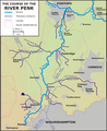 Penk Sketch Map.png 2,000 × 2,452; 274 KB
-
 Plan of the Creek at Holy Haven 1861.png 987 × 1,257; 249 KB
-
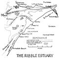 Ribble.Estuary.1917.jpg 1,800 × 1,763; 208 KB
-
 River crouch course.png 954 × 570; 62 KB
-
 River Eden map.png 2,003 × 2,363; 18.1 MB
-
 River Etherow map.png 1,084 × 576; 301 KB
-
 River Frome.jpg 1,086 × 674; 359 KB
-
 River Goyt map.png 639 × 638; 268 KB
-
 River Hull map.png 1,919 × 1,489; 1.52 MB
-
 River Kinder map.png 1,267 × 601; 161 KB
-
 River Mersey map.jpg 1,688 × 2,008; 911 KB
-
 River Mersey map.png 1,403 × 571; 1.18 MB
-
 River Mole Map.svg 450 × 515; 269 KB
-
 River Parrett map.png 765 × 1,018; 585 KB
-
 River Roch map.svg 1,052 × 744; 68 KB
-
 River Rother Dams.jpg 628 × 403; 54 KB
-
 River Sett map.png 1,035 × 605; 285 KB
-
 River Tame map.png 669 × 660; 361 KB
-
 River Tern Map.jpg 590 × 495; 193 KB
-
 River Ure overview map.png 1,440 × 812; 1.07 MB
-
 River Wey Map.png 1,045 × 799; 709 KB
-
 Rivers of Lancashire.png 600 × 714; 400 KB
-
 Rother (fleuve).png 910 × 392; 420 KB
-
 Salmons Brook catchment area.jpg 1,254 × 1,397; 354 KB
-
 Siston and Warmley Brooks map.png 777 × 1,303; 563 KB
-
 Smestow Sketchmap.png 2,764 × 4,068; 469 KB
-
 Stour Worcestershire.png 3,400 × 2,905; 669 KB
-
 Topography of Lancashire.png 682 × 812; 235 KB
-
 Wales.rivers.lakes.jpg 2,363 × 2,494; 676 KB
-
 Westbourne-route-1790.jpg 393 × 804; 108 KB
-
 River Wey Map 2.png 644 × 647; 85 KB
-
 Wom Brook (Miles).png 3,232 × 2,168; 775 KB
-
 Wom Brook Map.svg 1,488 × 1,050; 166 KB
-
 Wom Brook.png 3,200 × 2,106; 652 KB
-
 Реки во Британија.svg 1,104 × 1,586; 656 KB

_(14768413064).jpg)


.jpg)


.jpeg)


.png)


.png)


.png)