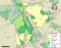
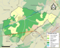
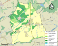
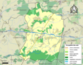
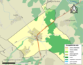
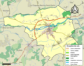
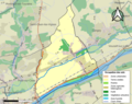
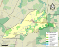
Category:Maps of land use of communes in Indre-et-Loire
Jump to navigation
Jump to search
Departments of Metropolitan France: Ain [01] · Aisne [02] · Allier [03] · Alpes-de-Haute-Provence [04] · Hautes-Alpes [05] · Alpes-Maritimes [06] · Ardèche [07] · Ardennes [08] · Ariège [09] · Aube [10] · Aude [11] · Aveyron [12] · Bouches-du-Rhône [13] · Calvados [14] · Cantal [15] · Charente [16] · Charente-Maritime [17] · Cher [18] · Corrèze [19] · Corse-du-Sud [2A]† · Haute-Corse [2B]† · Côte-d’Or [21] · Côtes-d'Armor [22] · Creuse [23] · Dordogne [24] · Doubs [25] · Drôme [26] · Eure [27] · Eure-et-Loir [28] · Finistère [29] · Gard [30] · Haute-Garonne [31] · Gers [32] · Gironde [33] · Hérault [34] · Ille-et-Vilaine [35] · Indre [36] · Indre-et-Loire [37] · Isère [38] · Jura [39] · Landes [40] · Loir-et-Cher [41] · Loire [42] · Haute-Loire [43] · Loire-Atlantique [44] · Loiret [45] · Lot [46] · Lot-et-Garonne [47] · Lozère [48] · Maine-et-Loire [49] · Manche [50] · Marne [51] · Haute-Marne [52] · Mayenne [53] · Meurthe-et-Moselle [54] · Meuse [55] · Morbihan [56] · Moselle [57] · Nièvre [58] · Nord [59] · Oise [60] · Orne [61] · Pas-de-Calais [62] · Puy-de-Dôme [63] · Pyrénées-Atlantiques [64] · Hautes-Pyrénées [65] · Pyrénées-Orientales [66] · Bas-Rhin [67] · Haut-Rhin [68] · departmental district of the Rhône [69] · Rhône [69D]‡ · Metropolis of Lyon [69M]‡ · Haute-Saône [70] · Saône-et-Loire [71] · Sarthe [72] · Savoie [73] · Haute-Savoie [74] · Seine-Maritime [76] · Seine-et-Marne [77] · Yvelines [78] · Deux-Sèvres [79] · Somme [80] · Tarn [81] · Tarn-et-Garonne [82] · Var [83] · Vaucluse [84] · Vendée [85] · Vienne [86] · Haute-Vienne [87] · Vosges [88] · Yonne [89] · Territoire de Belfort [90] · Essonne [91] · Hauts-de-Seine [92] · Seine-Saint-Denis [93] · Val-de-Marne [94] · Val-d'Oise [95]
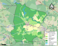
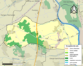
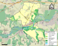
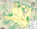
Media in category "Maps of land use of communes in Indre-et-Loire"
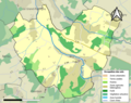
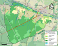
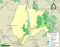
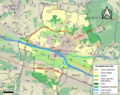
The following 200 files are in this category, out of 272 total.
(previous page) (next page)-
 37001-Abilly-Sols.png 3,270 × 2,598; 2.19 MB
-
 37002-Ambillou-Sols.png 3,270 × 2,598; 2.45 MB
-
 37003-Amboise-Sols.png 3,270 × 2,598; 3.21 MB
-
 37004-Anché-Sols.png 3,270 × 2,598; 1.78 MB
-
 37005-Antogny-le-Tillac-Sols.png 3,270 × 2,598; 1.66 MB
-
 37006-Artannes-sur-Indre-Sols.png 3,270 × 2,598; 2.97 MB
-
 37007-Assay-Sols.png 3,270 × 2,598; 1.46 MB
-
 37008-Athée-sur-Cher-Sols.png 3,270 × 2,598; 2.59 MB
-
 37009-Autrèche-Sols.png 3,270 × 2,598; 1.62 MB
-
 37010-Auzouer-en-Touraine-Sols.png 3,270 × 2,598; 2.5 MB
-
 37011-Avoine-Sols.png 3,270 × 2,598; 2.44 MB
-
 37012-Avon-les-Roches-Sols.png 3,270 × 2,598; 2.47 MB
-
 37013-Avrillé-les-Ponceaux-Sols.png 3,270 × 2,598; 1.81 MB
-
 37014-Azay-le-Rideau-Sols.png 3,270 × 2,598; 3.18 MB
-
 37015-Azay-sur-Cher-Sols.png 3,270 × 2,598; 2.79 MB
-
 37016-Azay-sur-Indre-Sols.png 3,270 × 2,598; 1.78 MB
-
 37018-Ballan-Miré-Sols.png 3,270 × 2,598; 4.24 MB
-
 37019-Barrou-Sols.png 3,270 × 2,598; 2.29 MB
-
 37020-Beaulieu-lès-Loches-Sols.png 3,270 × 2,598; 2.04 MB
-
 37021-Beaumont-Louestault-Sols.png 3,270 × 2,598; 2.76 MB
-
 37022-Beaumont-en-Véron-Sols.png 3,270 × 2,598; 2.95 MB
-
 37023-Beaumont-Village-Sols.png 3,270 × 2,598; 1.99 MB
-
 37024-Benais-Sols.png 3,270 × 2,598; 2.06 MB
-
 37025-Berthenay-Sols.png 3,270 × 2,598; 2.51 MB
-
 37026-Betz-le-Château-Sols.png 3,270 × 2,598; 1.9 MB
-
 37027-Bléré-Sols.png 3,270 × 2,598; 2.76 MB
-
 37028-Bossay-sur-Claise-Sols.png 3,270 × 2,598; 3.42 MB
-
 37029-Bossée-Sols.png 3,270 × 2,598; 1.63 MB
-
 37030-Le Boulay-Sols.png 3,270 × 2,598; 2.02 MB
-
 37031-Bourgueil-Sols.png 3,270 × 2,598; 3.07 MB
-
 37032-Bournan-Sols.png 3,270 × 2,598; 1.46 MB
-
 37033-Boussay-Sols.png 3,270 × 2,598; 2.29 MB
-
 37034-Braslou-Sols.png 3,270 × 2,598; 1.67 MB
-
 37035-Braye-sous-Faye-Sols.png 3,270 × 2,598; 1.85 MB
-
 37036-Braye-sur-Maulne-Sols.png 3,270 × 2,598; 1.46 MB
-
 37037-Brèches-Sols.png 3,270 × 2,598; 1.29 MB
-
 37038-Bréhémont-Sols.png 3,270 × 2,598; 2.57 MB
-
 37039-Bridoré-Sols.png 3,270 × 2,598; 1.78 MB
-
 37040-Brizay-Sols.png 3,270 × 2,598; 1.56 MB
-
 37041-Bueil-en-Touraine-Sols.png 3,270 × 2,598; 2.03 MB
-
 37042-Candes-Saint-Martin-Sols.png 3,270 × 2,598; 1.53 MB
-
 37043-Cangey-Sols.png 3,270 × 2,598; 2.89 MB
-
 37044-La Celle-Guenand-Sols.png 3,270 × 2,598; 1.81 MB
-
 37045-La Celle-Saint-Avant-Sols.png 3,270 × 2,598; 2.35 MB
-
 37046-Céré-la-Ronde-Sols.png 3,270 × 2,598; 2.15 MB
-
 37047-Cerelles-Sols.png 3,270 × 2,598; 1.98 MB
-
 37048-Chambon-Sols.png 3,270 × 2,598; 1.82 MB
-
 37049-Chambourg-sur-Indre-Sols.png 3,270 × 2,598; 2.08 MB
-
 37050-Chambray-lès-Tours-Sols.png 3,270 × 2,598; 4.65 MB
-
 37051-Champigny-sur-Veude-Sols.png 3,270 × 2,598; 2.01 MB
-
 37052-Chançay-Sols.png 3,270 × 2,598; 1.88 MB
-
 37053-Chanceaux-près-Loches-Sols.png 3,270 × 2,598; 1.68 MB
-
 37054-Chanceaux-sur-Choisille-Sols.png 3,270 × 2,598; 2.57 MB
-
 37055-Channay-sur-Lathan-Sols.png 3,270 × 2,598; 2.01 MB
-
 37056-La Chapelle-aux-Naux-Sols.png 3,270 × 2,598; 2.26 MB
-
 37057-La Chapelle-Blanche-Saint-Martin-Sols.png 3,270 × 2,598; 1.78 MB
-
 37058-La Chapelle-sur-Loire-Sols.png 3,270 × 2,598; 3.4 MB
-
 37059-Charentilly-Sols.png 3,270 × 2,598; 2.04 MB
-
 37060-Chargé-Sols.png 3,270 × 2,598; 1.96 MB
-
 37061-Charnizay-Sols.png 3,270 × 2,598; 2.33 MB
-
 37062-Château-la-Vallière-Sols.png 3,270 × 2,598; 2.06 MB
-
 37063-Château-Renault-Sols.png 3,270 × 2,598; 3.61 MB
-
 37064-Chaumussay-Sols.png 3,270 × 2,598; 1.65 MB
-
 37065-Chaveignes-Sols.png 3,270 × 2,598; 2.54 MB
-
 37066-Chédigny-Sols.png 3,270 × 2,598; 2.17 MB
-
 37067-Cheillé-Sols.png 3,270 × 2,598; 2.6 MB
-
 37068-Chemillé-sur-Dême-Sols.png 3,270 × 2,598; 2.05 MB
-
 37069-Chemillé-sur-Indrois-Sols.png 3,270 × 2,598; 1.97 MB
-
 37070-Chenonceaux-Sols.png 3,270 × 2,598; 1.65 MB
-
 37071-Chezelles-Sols.png 3,270 × 2,598; 1.69 MB
-
 37072-Chinon-Sols.png 3,270 × 2,598; 3.95 MB
-
 37073-Chisseaux-Sols.png 3,270 × 2,598; 1.65 MB
-
 37074-Chouzé-sur-Loire-Sols.png 3,270 × 2,598; 2.65 MB
-
 37075-Cigogné-Sols.png 3,270 × 2,598; 1.62 MB
-
 37076-Cinais-Sols.png 3,270 × 2,598; 1.9 MB
-
 37077-Cinq-Mars-la-Pile-Sols.png 3,270 × 2,598; 2.77 MB
-
 37078-Ciran-Sols.png 3,270 × 2,598; 1.91 MB
-
 37079-Civray-de-Touraine-Sols.png 3,270 × 2,598; 3.36 MB
-
 37080-Civray-sur-Esves-Sols.png 3,270 × 2,598; 1.38 MB
-
 37081-Cléré-les-Pins-Sols.png 3,270 × 2,598; 2.69 MB
-
 37082-Continvoir-Sols.png 3,270 × 2,598; 2.47 MB
-
 37083-Cormery-Sols.png 3,270 × 2,598; 2.25 MB
-
 37084-Couesmes-Sols.png 3,270 × 2,598; 2.11 MB
-
 37085-Courçay-Sols.png 3,270 × 2,598; 3.01 MB
-
 37086-Courcelles-de-Touraine-Sols.png 3,270 × 2,598; 2.03 MB
-
 37087-Courcoué-Sols.png 3,270 × 2,598; 1.72 MB
-
 37088-Couziers-Sols.png 3,270 × 2,598; 1.8 MB
-
 37089-Cravant-les-Côteaux-Sols.png 3,270 × 2,598; 2.27 MB
-
 37090-Crissay-sur-Manse-Sols.png 3,270 × 2,598; 1.58 MB
-
 37091-La Croix-en-Touraine-Sols.png 3,270 × 2,598; 2.49 MB
-
 37092-Crotelles-Sols.png 3,270 × 2,598; 1.88 MB
-
 37093-Crouzilles-Sols.png 3,270 × 2,598; 2.2 MB
-
 37094-Cussay-Sols.png 3,270 × 2,598; 1.83 MB
-
 37095-Dame-Marie-les-Bois-Sols.png 3,270 × 2,598; 1.26 MB
-
 37096-Dierre-Sols.png 3,270 × 2,598; 2.02 MB
-
 37097-Dolus-le-Sec-Sols.png 3,270 × 2,598; 2.18 MB
-
 37098-Draché-Sols.png 3,270 × 2,598; 2.4 MB
-
 37099-Druye-Sols.png 3,270 × 2,598; 1.84 MB
-
 37100-Épeigné-les-Bois-Sols.png 3,270 × 2,598; 1.58 MB
-
 37101-Épeigné-sur-Dême-Sols.png 3,270 × 2,598; 1.71 MB
-
 37103-Esves-le-Moutier-Sols.png 3,270 × 2,598; 1.24 MB
-
 37104-Esvres-Sols.png 3,270 × 2,598; 3.74 MB
-
 37105-Faye-la-Vineuse-Sols.png 3,270 × 2,598; 1.5 MB
-
 37106-La Ferrière-Sols.png 3,270 × 2,598; 1.3 MB
-
 37107-Ferrière-Larçon-Sols.png 3,270 × 2,598; 1.85 MB
-
 37108-Ferrière-sur-Beaulieu-Sols.png 3,270 × 2,598; 2.06 MB
-
 37109-Fondettes-Sols.png 3,270 × 2,598; 4.82 MB
-
 37110-Francueil-Sols.png 3,270 × 2,598; 2.11 MB
-
 37111-Genillé-Sols.png 3,270 × 2,598; 2.69 MB
-
 37112-Gizeux-Sols.png 3,270 × 2,598; 1.8 MB
-
 37113-Le Grand-Pressigny-Sols.png 3,270 × 2,598; 2 MB
-
 37114-La Guerche-Sols.png 3,270 × 2,598; 1.43 MB
-
 37115-Descartes-Sols.png 3,270 × 2,598; 2.52 MB
-
 37116-Les Hermites-Sols.png 3,270 × 2,598; 1.8 MB
-
 37117-Hommes-Sols.png 3,270 × 2,598; 1.88 MB
-
 37118-Huismes-Sols.png 3,270 × 2,598; 2.71 MB
-
 37119-L'Île-Bouchard-Sols.png 3,270 × 2,598; 2.24 MB
-
 37121-Jaulnay-Sols.png 3,270 × 2,598; 1.76 MB
-
 37122-Joué-lès-Tours-Sols.png 3,270 × 2,598; 5.65 MB
-
 37123-Langeais-Sols.png 3,270 × 2,598; 2.86 MB
-
 37124-Larçay-Sols.png 3,270 × 2,598; 3.83 MB
-
 37125-Lémeré-Sols.png 3,270 × 2,598; 1.84 MB
-
 37126-Lerné-Sols.png 3,270 × 2,598; 1.58 MB
-
 37127-Le Liège-Sols.png 3,270 × 2,598; 1.28 MB
-
 37128-Lignières-de-Touraine-Sols.png 3,270 × 2,598; 2.16 MB
-
 37129-Ligré-Sols.png 3,270 × 2,598; 2.42 MB
-
 37130-Ligueil-Sols.png 3,270 × 2,598; 2.11 MB
-
 37131-Limeray-Sols.png 3,270 × 2,598; 2.67 MB
-
 37132-Loches-Sols.png 3,270 × 2,598; 3.27 MB
-
 37133-Loché-sur-Indrois-Sols.png 3,270 × 2,598; 2.56 MB
-
 37134-Louans-Sols.png 3,270 × 2,598; 1.79 MB
-
 37136-Le Louroux-Sols.png 3,270 × 2,598; 2.11 MB
-
 37137-Lublé-Sols.png 3,270 × 2,598; 1.58 MB
-
 37138-Lussault-sur-Loire-Sols.png 3,270 × 2,598; 1.28 MB
-
 37139-Luynes-Sols.png 3,270 × 2,598; 3.57 MB
-
 37140-Luzé-Sols.png 3,270 × 2,598; 1.56 MB
-
 37141-Luzillé-Sols.png 3,270 × 2,598; 2.39 MB
-
 37142-Maillé-Sols.png 3,270 × 2,598; 2.49 MB
-
 37143-Manthelan-Sols.png 3,270 × 2,598; 2.19 MB
-
 37144-Marçay-Sols.png 3,270 × 2,598; 1.88 MB
-
 37145-Marcé-sur-Esves-Sols.png 3,270 × 2,598; 1.45 MB
-
 37146-Marcilly-sur-Maulne-Sols.png 3,270 × 2,598; 1.45 MB
-
 37147-Marcilly-sur-Vienne-Sols.png 3,270 × 2,598; 2.47 MB
-
 37148-Marigny-Marmande-Sols.png 3,270 × 2,598; 1.99 MB
-
 37149-Marray-Sols.png 3,270 × 2,598; 1.6 MB
-
 37150-Mazières-de-Touraine-Sols.png 3,270 × 2,598; 1.84 MB
-
 37151-La Membrolle-sur-Choisille-Sols.png 3,270 × 2,598; 2.72 MB
-
 37152-Mettray-Sols.png 3,270 × 2,598; 3.19 MB
-
 37153-Monnaie-Sols.png 3,270 × 2,598; 2.94 MB
-
 37154-Montbazon-Sols.png 3,270 × 2,598; 3.25 MB
-
 37155-Monthodon-Sols.png 3,270 × 2,598; 2.09 MB
-
 37156-Montlouis-sur-Loire-Sols.png 3,270 × 2,598; 3.58 MB
-
 37157-Montrésor-Sols.png 3,270 × 2,598; 1.4 MB
-
 37158-Montreuil-en-Touraine-Sols.png 3,270 × 2,598; 2.01 MB
-
 37159-Monts-Sols.png 3,270 × 2,598; 3.42 MB
-
 37160-Morand-Sols.png 3,270 × 2,598; 1.66 MB
-
 37161-Mosnes-Sols.png 3,270 × 2,598; 1.63 MB
-
 37162-Mouzay-Sols.png 3,270 × 2,598; 1.95 MB
-
 37163-Nazelles-Négron-Sols.png 3,270 × 2,598; 3.07 MB
-
 37165-Neuil-Sols.png 3,270 × 2,598; 1.53 MB
-
 37166-Neuillé-le-Lierre-Sols.png 3,270 × 2,598; 2.02 MB
-
 37167-Neuillé-Pont-Pierre-Sols.png 3,270 × 2,598; 2.09 MB
-
 37168-Neuilly-le-Brignon-Sols.png 3,270 × 2,598; 1.76 MB
-
 37169-Neuville-sur-Brenne-Sols.png 3,270 × 2,598; 2.01 MB
-
 37170-Neuvy-le-Roi-Sols.png 3,270 × 2,598; 2.82 MB
-
 37171-Noizay-Sols.png 3,270 × 2,598; 1.88 MB
-
 37172-Notre-Dame-d'Oé-Sols.png 3,270 × 2,598; 2.99 MB
-
 37173-Nouans-les-Fontaines-Sols.png 3,270 × 2,598; 3.02 MB
-
 37174-Nouâtre-Sols.png 3,270 × 2,598; 2.72 MB
-
 37175-Nouzilly-Sols.png 3,270 × 2,598; 2.62 MB
-
 37176-Noyant-de-Touraine-Sols.png 3,270 × 2,598; 2.26 MB
-
 37177-Orbigny-Sols.png 3,270 × 2,598; 2.83 MB
-
 37178-Panzoult-Sols.png 3,270 × 2,598; 2.59 MB
-
 37179-Parçay-Meslay-Sols.png 3,270 × 2,598; 3.21 MB
-
 37180-Parçay-sur-Vienne-Sols.png 3,270 × 2,598; 2.32 MB
-
 37181-Paulmy-Sols.png 3,270 × 2,598; 1.94 MB
-
 37182-Pernay-Sols.png 3,270 × 2,598; 1.74 MB
-
 37183-Perrusson-Sols.png 3,270 × 2,598; 2.97 MB
-
 37184-Le Petit-Pressigny-Sols.png 3,270 × 2,598; 1.9 MB
-
 37185-Pocé-sur-Cisse-Sols.png 3,270 × 2,598; 2.51 MB
-
 37186-Pont-de-Ruan-Sols.png 3,270 × 2,598; 2.01 MB
-
 37187-Ports-sur-Vienne-Sols.png 3,270 × 2,598; 1.71 MB
-
 37188-Pouzay-Sols.png 3,270 × 2,598; 2.24 MB
-
 37189-Preuilly-sur-Claise-Sols.png 3,270 × 2,598; 2.21 MB
-
 37190-Pussigny-Sols.png 3,270 × 2,598; 1.43 MB
-
 37191-Razines-Sols.png 3,270 × 2,598; 1.62 MB
-
 37192-Reignac-sur-Indre-Sols.png 3,270 × 2,598; 2.16 MB
-
 37193-Restigné-Sols.png 3,270 × 2,598; 2.77 MB
-
 37194-Reugny-Sols.png 3,270 × 2,598; 2.36 MB
-
 37195-La Riche-Sols.png 3,270 × 2,598; 3.77 MB
-
 37196-Richelieu-Sols.png 3,270 × 2,598; 1.71 MB
-
 37197-Rigny-Ussé-Sols.png 3,270 × 2,598; 1.94 MB
-
 37198-Rillé-Sols.png 3,270 × 2,598; 1.51 MB
-
 37199-Rilly-sur-Vienne-Sols.png 3,270 × 2,598; 2.04 MB
-
 37200-Rivarennes-Sols.png 3,270 × 2,598; 2.75 MB
-
 37201-Rivière-Sols.png 3,270 × 2,598; 1.74 MB
-
 37202-La Roche-Clermault-Sols.png 3,270 × 2,598; 3 MB
-
 37203-Rochecorbon-Sols.png 3,270 × 2,598; 3.83 MB
-
 37204-Rouziers-de-Touraine-Sols.png 3,270 × 2,598; 1.93 MB
-
 37205-Saché-Sols.png 3,270 × 2,598; 2.86 MB


Categories:
- Maps of land use of communes in Centre-Val de Loire
- Maps of land use of communes in France by department
- Maps of communes in Indre-et-Loire
- Maps of forests in Indre-et-Loire
- Maps of meadows in Indre-et-Loire
- Maps of arable land in Indre-et-Loire
- Maps of heterogenic agricultural zones in Indre-et-Loire
- Maps of urbanisation in Indre-et-Loire
- Maps of land use in Indre-et-Loire