Category:Maps of islands of Mexico
Jump to navigation
Jump to search
Countries of North America: Belize · Canada · Costa Rica · Honduras · Mexico · Nicaragua · Panama · United States of America‡
Other territories: British Virgin Islands
‡: partly located in North America
Other territories: British Virgin Islands
‡: partly located in North America
Subcategories
This category has the following 2 subcategories, out of 2 total.
*
- Locator maps of Mexican islands (21 F)
M
- Maps of Guadalupe Island (12 F)
Media in category "Maps of islands of Mexico"
The following 12 files are in this category, out of 12 total.
-
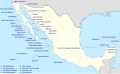 Islands of Mexico.svg 2,159 × 1,326; 474 KB
-

-

-

-
 Contour terrain of Aditnálta.jpg 3,508 × 4,967; 1.3 MB
-
 Iles de Basse-Californie Sud.jpg 720 × 540; 47 KB
-
 Isla Maria Madre.png 1,023 × 692; 1.06 MB
-
 Islas de Baja California.jpg 720 × 540; 59 KB
-
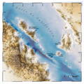
 Islas Maria.png 5,400 × 5,400; 20.29 MB
-

-

-
 Topographic map of the area around Isla Ángel de la Guarda.png 3,240 × 3,240; 14 MB

_(14763073031).jpg)
_(19354920172).jpg)
_(19361019585).jpg)


_esta_por_latitud_de_22._grados_19._minutos_en_el_meridiano_de_la_Vigia_de_Yxil_en_la_costa_de_Yucat%C3%A1n._LOC_90683650.jpg)
