Category:Maps of former colonies of Germany in Oceania
Jump to navigation
Jump to search
Subcategories
This category has the following 3 subcategories, out of 3 total.
Media in category "Maps of former colonies of Germany in Oceania"
The following 17 files are in this category, out of 17 total.
-
 Die deutschen Schutzgebiete (1898).tif 4,440 × 3,303; 41.98 MB
-
 East Asia and Oceania 1914 german.png 2,008 × 1,546; 463 KB
-
 East Asia and Oceania 1914-de.svg 2,613 × 2,013; 1.15 MB
-
 East Asia and Oceania 1914-en.svg 2,613 × 2,013; 1.15 MB
-
 East Asia and Oceania 1914-es.svg 2,613 × 2,013; 1.11 MB
-
 East Asia and Oceania 1914-fr.svg 2,613 × 2,013; 1.15 MB
-
 East Asia and Oceania 1914-no text.svg 2,613 × 2,013; 1.16 MB
-
 German Oceania, 1914.jpg 1,094 × 876; 224 KB
-
 German Pacific (loyal).svg 780 × 500; 148 KB
-
 German Pacific Colonies 1915 Map.png 2,000 × 1,213; 135 KB
-
 German Pacific.png 800 × 473; 40 KB
-
 German Pacific.svg 780 × 500; 148 KB
-
 Map of German colonies in South Pacific 1913.jpg 2,048 × 982; 382 KB
-
 Map of Germany's western Pacific colonies as of 1910 (map0005325727).jpg 3,000 × 2,073; 5.97 MB
-
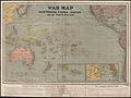 War map - Australia, China, Japan, and the South Pacific (1914).jpg 5,000 × 3,753; 13.05 MB
-
 Übersicht Der Deutschen Besitzungen im Stillen Ozean-Nauru.png 2,518 × 2,538; 4.49 MB
-
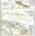 Übersicht Der Deutschen Besitzungen im Stillen Ozean.jpg 1,019 × 1,029; 391 KB


.svg)


.jpg)
.jpg)

