Category:Maps of forests in Orne
Jump to navigation
Jump to search
Departments of Metropolitan France: Ain [01] · Aisne [02] · Allier [03] · Alpes-de-Haute-Provence [04] · Hautes-Alpes [05] · Alpes-Maritimes [06] · Ardèche [07] · Ardennes [08] · Ariège [09] · Aube [10] · Aude [11] · Aveyron [12] · Bouches-du-Rhône [13] · Calvados [14] · Cantal [15] · Charente [16] · Charente-Maritime [17] · Cher [18] · Corrèze [19] · Corse-du-Sud [2A]† · Haute-Corse [2B]† · Côte-d’Or [21] · Côtes-d'Armor [22] · Creuse [23] · Dordogne [24] · Doubs [25] · Drôme [26] · Eure [27] · Eure-et-Loir [28] · Finistère [29] · Gard [30] · Haute-Garonne [31] · Gers [32] · Gironde [33] · Hérault [34] · Ille-et-Vilaine [35] · Indre [36] · Indre-et-Loire [37] · Isère [38] · Jura [39] · Landes [40] · Loir-et-Cher [41] · Loire [42] · Haute-Loire [43] · Loire-Atlantique [44] · Loiret [45] · Lot [46] · Lot-et-Garonne [47] · Lozère [48] · Maine-et-Loire [49] · Manche [50] · Marne [51] · Haute-Marne [52] · Mayenne [53] · Meurthe-et-Moselle [54] · Meuse [55] · Morbihan [56] · Moselle [57] · Nièvre [58] · Nord [59] · Oise [60] · Orne [61] · Pas-de-Calais [62] · Puy-de-Dôme [63] · Pyrénées-Atlantiques [64] · Hautes-Pyrénées [65] · Pyrénées-Orientales [66] · Bas-Rhin [67] · Haut-Rhin [68] · Rhône [69D]‡ · Haute-Saône [70] · Saône-et-Loire [71] · Sarthe [72] · Savoie [73] · Haute-Savoie [74] · Seine-Maritime [76] · Seine-et-Marne [77] · Yvelines [78] · Deux-Sèvres [79] · Somme [80] · Tarn [81] · Tarn-et-Garonne [82] · Var [83] · Vaucluse [84] · Vendée [85] · Vienne [86] · Haute-Vienne [87] · Vosges [88] · Yonne [89] · Territoire de Belfort [90] · Essonne [91] · Hauts-de-Seine [92] · Seine-Saint-Denis [93] · Val-de-Marne [94] · Val-d'Oise [95]
Subcategories
This category has only the following subcategory.
M
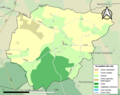
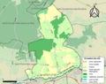
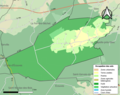
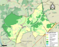
Media in category "Maps of forests in Orne"
The following 60 files are in this category, out of 60 total.
-
 61002-Almenêches-Sols.png 3,270 × 2,598; 1.8 MB
-
 61013-Aunay-les-Bois-Sols.png 3,270 × 2,598; 1.13 MB
-
 61014-Aunou-le-Faucon-Sols.png 3,270 × 2,598; 1.31 MB
-
 61023-Bailleul-Sols.png 3,270 × 2,598; 1.69 MB
-
 61032-Beaufai-Sols.png 3,270 × 2,598; 1.73 MB
-
 61039-La Bellière-Sols.png 3,270 × 2,598; 1.51 MB
-
 61052-Bonnefoi-Sols.png 3,270 × 2,598; 1.31 MB
-
 61056-Le Bouillon-Sols.png 3,270 × 2,598; 1.32 MB
-
 61061-Bretoncelles-Sols.png 3,270 × 2,598; 2.32 MB
-
 61062-Brieux-Sols.png 3,270 × 2,598; 1.27 MB
-
 61074-Carrouges-Sols.png 3,270 × 2,598; 1.57 MB
-
 61076-Le Cercueil-Sols.png 3,270 × 2,598; 1.09 MB
-
 61080-Chahains-Sols.png 3,270 × 2,598; 1.47 MB
-
 61091-Champsecret-Sols.png 3,270 × 2,598; 2.67 MB
-
 61094-La Chapelle-au-Moine-Sols.png 3,270 × 2,598; 1.42 MB
-
 61097-La Chapelle-Montligeon-Sols.png 3,270 × 2,598; 1.36 MB
-
 61098-La Chapelle-près-Sées-Sols.png 3,270 × 2,598; 1.6 MB
-
 61103-Chaumont-Sols.png 3,270 × 2,598; 1.33 MB
-
 61108-Cisai-Saint-Aubin-Sols.png 3,270 × 2,598; 1.43 MB
-
 61141-Cuissai-Sols.png 3,270 × 2,598; 1.44 MB
-
 61160-Feings-Sols.png 3,270 × 2,598; 1.57 MB
-
 61162-La Ferrière-au-Doyen-Sols.png 3,270 × 2,598; 1.97 MB
-
 61164-La Ferrière-Béchet-Sols.png 3,270 × 2,598; 1.34 MB
-
 61187-Les Genettes-Sols.png 3,270 × 2,598; 1.34 MB
-
 61206-L'Hôme-Chamondot-Sols.png 3,270 × 2,598; 1.24 MB
-
 61216-La Lande-de-Goult-Sols.png 3,270 × 2,598; 1.68 MB
-
 61228-L'Orée-d'Écouves-Sols.png 3,270 × 2,598; 2.14 MB
-
 61230-Longny les Villages-Sols.png 3,270 × 2,598; 3.7 MB
-
 61241-La Madeleine-Bouvet-Sols.png 3,270 × 2,598; 1.44 MB
-
 61242-Le Mage-Sols.png 3,270 × 2,598; 2.07 MB
-
 61243-Magny-le-Désert-Sols.png 3,270 × 2,598; 3.05 MB
-
 61251-Marchemaisons-Sols.png 3,270 × 2,598; 1.41 MB
-
 61259-Le Ménil-Bérard-Sols.png 3,270 × 2,598; 1.03 MB
-
 61283-Montabard-Sols.png 3,270 × 2,598; 1.5 MB
-
 61288-Montmerrei-Sols.png 3,270 × 2,598; 1.63 MB
-
 61300-Moutiers-au-Perche-Sols.png 3,270 × 2,598; 1.99 MB
-
 61326-Perrou-Sols.png 3,270 × 2,598; 1,005 KB
-
 61341-Écouves-Sols.png 3,270 × 2,598; 2.27 MB
-
 61345-Rémalard en Perche-Sols.png 3,270 × 2,598; 2.65 MB
-
 61357-Rouperroux-Sols.png 3,270 × 2,598; 1.24 MB
-
 61376-Saint-Clair-de-Halouze-Sols.png 3,270 × 2,598; 1.66 MB
-
 61382-Saint-Denis-sur-Sarthon-Sols.png 3,270 × 2,598; 2.03 MB
-
 61386-Saint-Evroult-Notre-Dame-du-Bois-Sols.png 3,270 × 2,598; 1.91 MB
-
 61400-Saint-Gervais-du-Perron-Sols.png 3,270 × 2,598; 1.75 MB
-
 61418-Saint-Mard-de-Réno-Sols.png 3,270 × 2,598; 1.48 MB
-
 61424-Saint-Martin-des-Landes-Sols.png 3,270 × 2,598; 1.29 MB
-
 61429-Charencey-Sols.png 3,270 × 2,598; 2.18 MB
-
 61432-Saint-Michel-Tubœuf-Sols.png 3,270 × 2,598; 1.94 MB
-
 61433-Saint-Nicolas-des-Bois-Sols.png 3,270 × 2,598; 1.54 MB
-
 61446-Saint-Pierre-des-Loges-Sols.png 3,270 × 2,598; 1.21 MB
-
 61456-Saint-Sulpice-sur-Risle-Sols.png 3,270 × 2,598; 3.1 MB
-
 61463-Les Monts-d'Andaine-Sols.png 3,270 × 2,598; 2.49 MB
-
 61474-Gouffern en Auge-Sols.png 3,270 × 2,598; 4.49 MB
-
 61475-Soligny-la-Trappe-Sols.png 3,270 × 2,598; 2 MB
-
 61480-Tanville-Sols.png 3,270 × 2,598; 1.14 MB
-
 61488-Touquettes-Sols.png 3,270 × 2,598; 1.21 MB
-
 61491-Tourouvre au Perche-Sols.png 3,270 × 2,598; 3.44 MB
-
 61499-Les Ventes-de-Bourse-Sols.png 3,270 × 2,598; 1.72 MB
-
 61500-La Ventrouze-Sols.png 3,270 × 2,598; 1.08 MB
-
 61505-Villedieu-lès-Bailleul-Sols.png 3,270 × 2,598; 1.38 MB


