Category:Maps of districts of Austria
Jump to navigation
Jump to search
Deutsch: Karten der Bezirke Österreichs (84) einschliesslich Statutarstädte (15) und den 2 Exposituren, siehe Liste der Bezirke und Statutarstädte in Österreich.
Sortiert nach Namen (Bitte Umlaute durch einfachen Vokal ersetzen, ß durch ss, „Sankt“ unter «St.»)
Sortiert nach Namen (Bitte Umlaute durch einfachen Vokal ersetzen, ß durch ss, „Sankt“ unter «St.»)
English: Maps of Austrian districts, including statuary cities (Statutarstädte) and Exposituren, sorted by (german!) name
Subcategories
This category has the following 9 subcategories, out of 9 total.
*
M
Media in category "Maps of districts of Austria"
The following 8 files are in this category, out of 8 total.
-
 Bezirke Österreich Kennzeichen nach Bundesländern.jpg 2,750 × 2,300; 964 KB
-
 AT-Bezirke - blank.svg 800 × 413; 832 KB
-
 Austrian Districts 2020 template.svg 1,000 × 524; 175 KB
-
 Austrian Districts.svg 800 × 413; 1.14 MB
-
 Autokennzeichen Österreich svenska.png 2,750 × 2,300; 1.19 MB
-
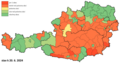 Chybějící články Rakousko.png 2,560 × 1,341; 413 KB
-
 Gemeinden Österreichs 2022.png 5,000 × 2,892; 3.7 MB
-
 Österreich Statutarstädte.jpg 2,750 × 1,500; 550 KB


