Category:Maps of airports in the United States
Jump to navigation
Jump to search

|
All transport map images in this category could be re-created using vector graphics as SVG files. This has several advantages; see Commons:Media for cleanup for more information. If an SVG form of this image is available, please upload it and afterwards replace this template with
{{vector version available|new image name}}. |
Subcategories
This category has the following 5 subcategories, out of 5 total.
O
T
- Terminal area charts (4 F)
Media in category "Maps of airports in the United States"
The following 52 files are in this category, out of 52 total.
-
 1962 Topographical Map of Abandoned Bong Air Force Base.jpg 962 × 749; 597 KB
-
 AirTrain-JFK-Map.png 1,273 × 1,707; 264 KB
-
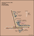 AnchorageAirport.png 612 × 636; 43 KB
-
 Andrews County Airport Map.svg 605 × 929; 1.4 MB
-
 ATL Diagram.pdf 806 × 1,237; 370 KB
-
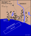 Bethel-Seaplane-Base-diagram.png 498 × 572; 47 KB
-
 Capital Region International Airport Topo USGS 01-Jul-80.jpg 650 × 450; 175 KB
-
 CGA.png 496 × 570; 36 KB
-
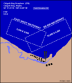 Chignik-Bay-Seaplane-Base-diagram.png 496 × 570; 36 KB
-
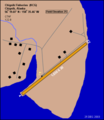 Chignik-Fisheries-Airport-diagram.png 496 × 570; 38 KB
-
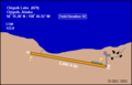 Chignik-Lake-Airport-diagram.png 496 × 319; 17 KB
-
 Davis Airport Michigan Topo USGS 01-Jul-80.jpg 640 × 480; 62 KB
-
 DeadhorseAirport.png 434 × 325; 61 KB
-
 Denver Municipal Airport - DPLA - 08e913b1cebe0d5b215f5fb7d59e1893.jpg 7,447 × 8,999; 5.95 MB
-
 Diagram of Chevak Airport in Chevak, Alaska.png 372 × 428; 59 KB
-
 Diagram of Lake Hood Seaplane Base.jpg 498 × 572; 34 KB
-
 EDF.png 498 × 708; 80 KB
-
 FairbanksAirport.png 524 × 599; 61 KB
-
 FBK.png 725 × 555; 114 KB
-
 Fort Lauderdale Hollywood Airport Terminal Map.png 806 × 428; 53 KB
-
 HAY.png 496 × 570; 44 KB
-
 Hicks Airfield Map.jpg 506 × 392; 27 KB
-
 HNL Destinations 01-2013.jpg 2,000 × 1,125; 106 KB
-
 Hollis-Seaplane-Base-diagram.png 496 × 570; 52 KB
-
 Hsvfaa.jpg 965 × 1,481; 138 KB
-
 IFR Approach Chart, Bozeman, Montana (USA),.jpg 4,096 × 5,840; 2.77 MB
-
 IYS.png 496 × 570; 37 KB
-
 Kulik-Lake-Airport-diagram.gif 496 × 570; 35 KB
-
 KWHPdgmjpg.jpg 806 × 1,237; 255 KB
-
 Laurence G. Hanscom Air Force Base - NARA - 7347130.jpg 4,889 × 3,304; 2.52 MB
-
 MAF airport map.PNG 516 × 792; 66 KB
-
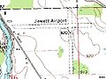 Mason Jewett Field Topo USGS 1-Jul-76.jpg 640 × 480; 92 KB
-
 MuskegonCountyAirportFAADiagram.pdf 806 × 1,237; 122 KB
-
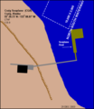
 Naknek-Airport-diagram.png 496 × 570; 53 KB
-
 NavalOutlyingFieldClarksDryLake1945.jpg 820 × 498; 31 KB
-
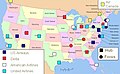 North american airline hubs map.jpg 575 × 354; 151 KB
-
 PIA Route Map.PNG 800 × 495; 101 KB
-
 Port-Heiden-Airport-diagram.png 496 × 570; 41 KB
-
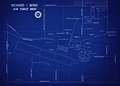 Richard Ira Bong Air Force Base Map.jpg 6,261 × 4,476; 14.01 MB
-
 Saginaw Airport Map.jpg 356 × 307; 14 KB
-
 SeaplaneBaseWileyPostOperationsArea.jpg 1,139 × 782; 147 KB
-
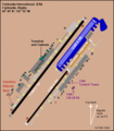
 SID Chart, Coaldale Two Departure, Fresno-Yosemite, 2016.jpg 3,277 × 4,872; 1.32 MB
-
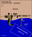 Tenakee Seaplane Base diagram.png 496 × 570; 39 KB
-
 TokeenSPB-diagram.png 496 × 570; 37 KB
-
 Tyonek-Airport-diagram.png 496 × 570; 45 KB
-
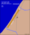
 Vail CA 41sect.jpg 434 × 221; 21 KB
-
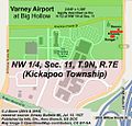 Varney at Big Hollow (Map).jpg 502 × 479; 202 KB
-
 Varney at Kellar (Map).jpg 525 × 511; 253 KB
-
 Waterfall-SPB-diagram.gif 496 × 570; 55 KB
-
 Westchester County Airport Diagram.gif 387 × 594; 45 KB
-
 Z53.png 496 × 570; 25 KB
-
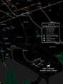
 ナッシュビル国際空港-位置地図.jpg 1,024 × 756; 284 KB


,.jpg)


.jpg)
.jpg)


