Category:Maps of West Coast Region
Jump to navigation
Jump to search
Regions of New Zealand: Auckland · Bay of Plenty · Canterbury · Hawke's Bay · Marlborough · Nelson · Otago · Southland · Tasman · Waikato · Wellington · West Coast
Outlying islands, territories and dependencies: Auckland Islands · Chatham Islands · Kermadec Islands · Tokelau – Territory with specific status: Ross Dependency
Associated countries: Cook Islands · Niue
Outlying islands, territories and dependencies: Auckland Islands · Chatham Islands · Kermadec Islands · Tokelau – Territory with specific status: Ross Dependency
Associated countries: Cook Islands · Niue
| NO WIKIDATA ID FOUND! Search for Maps of West Coast Region on Wikidata | |
| Upload media |
Subcategories
This category has only the following subcategory.
Media in category "Maps of West Coast Region"
The following 5 files are in this category, out of 5 total.
-
 1884 map.jpg 2,699 × 4,111; 2.94 MB
-
 Admiralty Chart No 2590 R. Awarua to R. Waiau, Published 1959.jpg 11,194 × 8,482; 25.71 MB
-
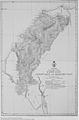
 Arahura Deed map.jpg 877 × 1,306; 360 KB
-
 Hokitika Borough map.jpg 14,017 × 12,736; 28.17 MB
-
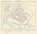
 Map of Brunner Borough.jpg 10,342 × 8,826; 10.71 MB


