Category:Maps of Saint Matthew Island
Jump to navigation
Jump to search
Media in category "Maps of Saint Matthew Island"
The following 4 files are in this category, out of 4 total.
-
 Operational Navigation chart D-10, 4th edition.jpg 9,254 × 6,676; 12.95 MB
-
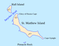 St. Matthew Island and Hall Island map (eng).svg 458 × 361; 27 KB
-
 St. Matthew Island and Hall Island map (rus).svg 458 × 361; 146 KB
-
 Stmatthewisland.png 2,929 × 1,713; 51 KB

.svg)
.svg)
