Category:Maps of Putnam County, Ohio
Jump to navigation
Jump to search
Wikimedia category | |||||
| Upload media | |||||
| Instance of | |||||
|---|---|---|---|---|---|
| Category combines topics | |||||
| Putnam County | |||||
county in Ohio, United States | |||||
| Instance of | |||||
| Named after | |||||
| Location | Ohio | ||||
| Capital | |||||
| Inception |
| ||||
| Population |
| ||||
| Area |
| ||||
| Different from | |||||
| official website | |||||
 | |||||
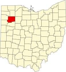
Putnam County is in northwest Ohio in the United States. Its county seat is Ottawa.
Subcategories
This category has the following 2 subcategories, out of 2 total.
Media in category "Maps of Putnam County, Ohio"
The following 35 files are in this category, out of 35 total.
-
1880 Map of Sugar Creek Township.jpg 1,745 × 759; 517 KB
-
1898 PUTNAM COUNTY RAILROAD MAP.jpg 379 × 297; 53 KB
-
Greensburg Putnam.PNG 627 × 455; 19 KB
-
Jackson Putnam2.PNG 627 × 455; 19 KB
-
Jennings Putnam.PNG 627 × 455; 19 KB
-
Liberty Putnam.PNG 627 × 455; 19 KB
-
Map of Ohio highlighting Putnam County.svg 1,050 × 1,141; 37 KB
-
Monroe Putnam.PNG 627 × 455; 19 KB
-
Monterey Putnam.PNG 627 × 455; 19 KB
-
OHMap-doton-Belmore.png 274 × 300; 10 KB
-
OHMap-doton-Cloverdale.png 274 × 300; 10 KB
-
OHMap-doton-Columbus Grove.png 274 × 300; 10 KB
-
OHMap-doton-Continental.png 274 × 300; 10 KB
-
OHMap-doton-Dupont.png 274 × 300; 10 KB
-
OHMap-doton-Fort Jennings.png 274 × 300; 10 KB
-
OHMap-doton-Gilboa.png 274 × 300; 10 KB
-
OHMap-doton-Glandorf.png 274 × 300; 10 KB
-
OHMap-doton-Kalida.png 274 × 300; 10 KB
-
OHMap-doton-Leipsic.png 274 × 300; 10 KB
-
OHMap-doton-Miller City.png 274 × 300; 10 KB
-
OHMap-doton-Ottawa.png 274 × 300; 10 KB
-
OHMap-doton-Ottoville.png 274 × 300; 10 KB
-
OHMap-doton-Pandora.png 274 × 300; 10 KB
-
OHMap-doton-Rimer.png 309 × 352; 17 KB
-
OHMap-doton-Vaughnsville.png 309 × 352; 17 KB
-
OHMap-doton-West Leipsic.png 274 × 300; 10 KB
-
Ottawa Putnam.PNG 627 × 455; 19 KB
-
Palmer Putnam.PNG 627 × 455; 19 KB
-
Perry Putnam.PNG 627 × 455; 19 KB
-
Pleasant Putnam.PNG 627 × 455; 19 KB
-
Riley Putnam.PNG 627 × 455; 19 KB
-
Sugar Creek Putnam.PNG 627 × 455; 19 KB
-
Union Putnam.PNG 627 × 455; 19 KB
-
Van Buren Putnam.PNG 627 × 455; 19 KB
-
Vaughnsville Map as of 1895 Atlas.jpg 678 × 568; 182 KB

