
Category:Maps of Potsdam District (GDR)
Media in category "Maps of Potsdam District (GDR)"
The following 23 files are in this category, out of 23 total.
-
 Bezirk Potsdam in East Germany.svg 554 × 727; 215 KB
-
 Bezirk Potsdam.png 1,500 × 2,036; 76 KB
-
 Brandenburgobgpdm.png 356 × 350; 8 KB
-
 DDR-Bezirk-Potsdam.png 1,500 × 2,036; 56 KB
-
 District of Potsdam in German Democratic Republic (-water).svg 618 × 789; 992 KB
-
 District of Potsdam in German Democratic Republic.svg 618 × 789; 985 KB
-
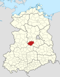 Belzig in German Democratic Republic.svg 618 × 789; 3 MB
-
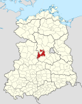
 Brandenburg in German Democratic Republic.svg 618 × 789; 3 MB
-
 Brandenburg Land in German Democratic Republic.svg 618 × 789; 3 MB
-
 Gransee in German Democratic Republic.svg 618 × 789; 3 MB
-
 Jüterbog in German Democratic Republic.svg 618 × 789; 3 MB
-
 Königs Wusterhausen in German Democratic Republic.svg 618 × 789; 3 MB
-
 Kyritz in German Democratic Republic.svg 618 × 789; 3 MB
-
 Luckenwalde in German Democratic Republic.svg 618 × 789; 3 MB
-
 Nauen in German Democratic Republic.svg 618 × 789; 3 MB
-
 Neuruppin in German Democratic Republic.svg 618 × 789; 3 MB
-
 Oranienburg in German Democratic Republic.svg 618 × 789; 3 MB
-
 Potsdam in German Democratic Republic.svg 618 × 789; 3 MB
-
 Potsdam Land in German Democratic Republic.svg 618 × 789; 3 MB
-
 Pritzwalk in German Democratic Republic.svg 618 × 789; 3 MB
-
 Rathenow in German Democratic Republic.svg 618 × 789; 3 MB
-
 Wittstock in German Democratic Republic.svg 618 × 789; 3 MB
-
 Zossen in German Democratic Republic.svg 618 × 789; 3 MB


.svg)


