Category:Maps of Paris by Braun & Hogenberg
Jump to navigation
Jump to search
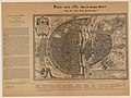
English: The Braun map of Paris depicts the city with a bird's-eye view to the east as it appeared around 1530. The map includes the city wall of Philippe Auguste, and shows gates in the section of the wall on the Right Bank, which would be pulled down after 1530. It was first published in Cologne in 1572 as the sixth plate (unnumbered) in Civitates Orbis Terrarum, Liber primus by Georg Braun, Simon Van der Novel, and Franz Hogenberg. Braun was the cartographer, and Van der Novel and Hogenberg, the engravers. The scale is approximately 1 to 10,000. It was printed from an engraved copper plate, 34 cm high x 48.3 cm wide. The title is in Latin, beginning "Lutetia, vulgari nomine Paris..." ("Lutetia, commonly called Paris..."). Lutetia was the Roman and pre-Roman name for Paris. The topographical names are in French. The view and area covered by the map, like most maps of Paris published in the 16th century, are nearly identical to that of Sebastian Münster's map of Paris (see File:Plan de Paris vers 1550-2.jpg), which first appeared in a 1550 edition (pp. 88–89) of his Cosmographie (initially published in 1544). It has been postulated that all of these early and closely related maps were based on a large prototype created between 1523 and 1530, although there is no documentation that such a map actually existed.
Sources
[edit]- Ballon, Hilary (1991). The Paris of Henri IV: Architecture and Urbanism, pp. 343–344, note 30. Cambridge, Massachusetts: The MIT Press. ISBN 9780262023092.
- Boutier, Jean (2007). Les Plans de Paris, second edition, pp. 78–79, 95–97. Paris: Bibliothèque nationale de France. ISBN 9782717723892.
Subcategories
This category has the following 2 subcategories, out of 2 total.
Media in category "Maps of Paris by Braun & Hogenberg"
The following 38 files are in this category, out of 38 total.
-
 Braun Paris HAAB - original.jpg 6,400 × 4,952; 16.08 MB
-
 Braun Paris HAAB.jpg 5,936 × 4,228; 22.23 MB
-
 1572 map of Paris by Georg Braun & Frans Hogenberg.jpg 12,265 × 8,931; 31.44 MB
-
 Atlas des anciens plans de Paris - 042. Paris in 1530 - David Rumsey.jpg 17,300 × 12,548; 48.99 MB
-
 Atlas des anciens plans de Paris - Georges Braun, Paris en 1530 - David Rumsey.jpg 11,900 × 9,400; 67.84 MB
-

-
 Beschreibung der Städt der Welt - Braun & Hogenberg - btv1b52512111k (035 of 378).jpg 8,250 × 6,350; 9.31 MB
-

-

-
 Braun Paris UBHD.jpg 2,124 × 1,524; 2.89 MB
-
 Frans Hogenberg, Lutetia, vulgari nomine Paris, urbs Gallia maxima (FL17237429 3478224).jpg 12,957 × 9,375; 175.36 MB
-
 Georg Braun, Lutetia, vulgari nomine Paris, 1575 - David Rumsey.jpg 9,146 × 6,601; 46.61 MB
-
 Georg Braun, Paris vers 1530 - Plan de Georges Braun, 1908 - Gallica.jpg 10,842 × 8,161; 13.73 MB
-
 Lutetia vulgari nomine Paris (...) (BM 1869,0710.40).jpg 2,500 × 1,783; 1.55 MB
-
 Lutetia vulgari nomine Paris, 1574 by Georg Braun - Gallica.jpg 8,874 × 6,491; 27.88 MB
-
 Lutetia vulgari nomine Paris, urbs Galliae maxima, 1572 - Gallica.jpg 8,057 × 5,986; 5.82 MB
-
 Lutetia vulgari nomine Paris, urbs Galliae maxima, 1572 by Georg Braun - Gallica.jpg 6,850 × 5,172; 5.06 MB
-
 Lutetia vulgari nomine Paris, urbs Galliae maxima, 1645 by Georg Braun - Gallica.jpg 6,388 × 4,832; 5.69 MB
-

-
 Lutetia vulgari nomine Paris, urbs Galliae maxima... - btv1b55004542h.jpg 6,850 × 5,172; 4.88 MB
-
 Lutetia vulgari nomine Paris, urbs Galliae maxima..., 1599 - Gallica.jpg 6,404 × 4,952; 16.75 MB
-

-
 Lutetia, vulgari nomine Paris, urbs Galliæ maxima - UWM Libraries.jpg 6,150 × 4,500; 14.78 MB
-
 Lvtetia - vulgari nomine Paris by Braun and Hogenberg, 1574 - Stanford Libraries.jpg 13,082 × 9,943; 40.97 MB
-
 Maps of Paris by Braun & Hogenberg - Bukowskis.jpg 4,235 × 3,347; 8.99 MB
-
 Maps of Paris by Braun & Hogenberg - Sanderus Antiquariaat.jpg 2,500 × 1,784; 1.83 MB
-
 Munser1572.jpg 1,372 × 977; 1.17 MB
-
 Notre-Dame de Paris, Livre troisième - Le plus ancien plan de Paris - Paris Musées.jpg 3,000 × 2,250; 1.75 MB
-
 Paris en 1530, Fac-similé du plan de Georges Braun - Paris Musées.jpg 8,960 × 6,568; 39.82 MB
-
 Paris vers 1530 (Plan de Georges Braun) - Paris Musées.jpg 7,040 × 6,184; 33.39 MB
-
 Paris vers 1530 (Plan de Georges Braun). Plan dit Aux Trois Personnages, 1908 - Gallica.jpg 7,973 × 5,977; 10.01 MB
-
 Paris vers 1530 - (Plan de Georges Braun), Plan dit "Aux trois personnages" - btv1b84446897.jpg 10,842 × 8,161; 12.91 MB
-
 Plan de Paris en 1572.jpg 2,864 × 2,084; 1.59 MB
-
 Plan dit de Braun - Paris au 16ème siècle - Paris Musées (text).jpg 4,697 × 3,474; 1.72 MB
-
 Plan dit de Braun - Paris au 16ème siècle - Paris Musées.jpg 6,320 × 4,736; 25.05 MB
-
 Plan dit de Braun, Paris au 16ème siècle Paris Musées.jpg 6,912 × 5,240; 27.59 MB
-
 Wolf-Dietrich-Klebeband Städtebilder G 117 III.jpg 2,000 × 1,453; 1.34 MB
-
 Civitates orbis terrarvm, liber primvs 1577 (107273479).jpg 15,617 × 11,045; 26.68 MB


.jpg)


.jpg)


_(BM_1869,0710.40).jpg)


tia_universitate_excellenti_stupendi_operis_templo_B._Mariae,_Palatio_Regio..._-_btv1b531788477_(1_of_2).jpg)


_-_Paris_Mus%C3%A9es.jpg)
._Plan_dit_Aux_Trois_Personnages,_1908_-_Gallica.jpg)
,_Plan_dit_%22Aux_trois_personnages%22_-_btv1b84446897.jpg)

.jpg)


.jpg)