Category:Maps of Paris by Albert Jouvin de Rochefort
Jump to navigation
Jump to search
- Maps of Paris by Jouvin de Rochefort (Click on the blue link to reach the category)
-
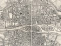
![Boutier 112 [1672–1674] – 1714](https://upload.wikimedia.org/wikipedia/commons/thumb/f/f0/Atlas_des_anciens_plans_de_Paris_-_Paris_en_1672_-_David_Rumsey.jpg/215px-Atlas_des_anciens_plans_de_Paris_-_Paris_en_1672_-_David_Rumsey.jpg)
-
![Boutier 116 1676 – [after 1679]](https://upload.wikimedia.org/wikipedia/commons/thumb/7/7e/Atlas_des_anciens_plans_de_Paris_-_Paris_en_1676_-_David_Rumsey.jpg/224px-Atlas_des_anciens_plans_de_Paris_-_Paris_en_1676_-_David_Rumsey.jpg)
-
 Boutier 132
1692 -

-
![Boutier 139 1697; 1719; [1721–1722]](https://upload.wikimedia.org/wikipedia/commons/thumb/6/60/Atlas_des_anciens_plans_de_Paris_-_Paris_en_1697_-_David_Rumsey.jpg/230px-Atlas_des_anciens_plans_de_Paris_-_Paris_en_1697_-_David_Rumsey.jpg)
![Boutier 112 [1672–1674] – 1714](/wiki/File:Atlas_des_anciens_plans_de_Paris_-_Paris_en_1672_-_David_Rumsey.jpg)
![Boutier 116 1676 – [after 1679]](/wiki/File:Atlas_des_anciens_plans_de_Paris_-_Paris_en_1676_-_David_Rumsey.jpg)


![Boutier 139 1697; 1719; [1721–1722]](/wiki/File:Atlas_des_anciens_plans_de_Paris_-_Paris_en_1697_-_David_Rumsey.jpg)
- Boutier, Jean (2007). Les Plans de Paris des origines (1493) à la fin de XVIIIe siècle, second edition. Paris: Bibliothèque nationale de France. ISBN 9782717723892.
Subcategories
This category has the following 5 subcategories, out of 5 total.
Media in category "Maps of Paris by Albert Jouvin de Rochefort"
The following 3 files are in this category, out of 3 total.
-
 1714 - Diocèse de l'Archevesché de Paris - Open Data Hauts-de-Seine.jpg 6,371 × 8,877; 43.28 MB
-
 Map of Paris 1692 – Boutier 2007 cat. no. 132 p. 182.jpg 4,136 × 2,772; 3.65 MB
-
 Plan Jouvin de Rochefort (1672).pdf 2,989 × 2,300; 49.87 MB
