Category:Map of Paris by Jouvin de Rochefort (Boutier 112)
Jump to navigation
Jump to search
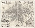
English: There are at least five editions of this map (originally engraved by François de La Pointe), dating from [1672–1674] to 1714. The plan consists of 9 plates, 49.5 cm x 60 cm (1st and 3rd rows), 48.5 cm x 60 cm (2nd row), 141.5 cm x 174 cm assembled, at a scale of around 1 to 4,600. Pinon and Le Boudec refer to it as the "Grand plan de Jouvin de Rochefort", although they mistakenly reproduce Boutier 139. A 1/4-reduced heliogravure facsimile of the first [1672–1674] plan was published in Atlas des anciens plans de Paris (1880, 1900), plate XX "Paris en 1672", 4 plates, 58 cm x 67 cm each.
- Boutier, Jean (2007). Les Plans de Paris des origines (1493) à la fin de XVIIIe siècle, second edition. Paris: Bibliothèque nationale de France. ISBN 9782717723892.
- Pinon, Pierre; Bertrand Le Boudec; Dominique Carré (2004). Les plans de Paris. Paris: Bibliothèque nationale de France. ISBN 9782847420616.
Media in category "Map of Paris by Jouvin de Rochefort (Boutier 112)"
The following 16 files are in this category, out of 16 total.
-
 1672 Plan de Jouvin de Rochefort.jpg 6,584 × 5,349; 11.94 MB
-
 1675 Rochefort Map of Paris.jpg 9,000 × 7,490; 24.9 MB
-
 Atlas des anciens plans de Paris - 070. Paris in 1672 - David Rumsey.jpg 24,867 × 17,821; 104.96 MB
-
 Atlas des anciens plans de Paris - 071. Paris in 1672 - David Rumsey.jpg 25,070 × 18,004; 110.54 MB
-
 Atlas des anciens plans de Paris - 072. Paris in 1672 - David Rumsey.jpg 24,871 × 17,979; 96.87 MB
-
 Atlas des anciens plans de Paris - 073. Paris in 1672 - David Rumsey.jpg 25,104 × 17,766; 91.91 MB
-
 Atlas des anciens plans de Paris - 074. Paris in 1672 - David Rumsey.jpg 41,351 × 31,331; 333.96 MB
-
 Atlas des anciens plans de Paris - Paris en 1672 - BHVP.jpg 8,337 × 6,725; 54.81 MB
-
 Atlas des anciens plans de Paris - Paris en 1672 - David Rumsey.jpg 30,000 × 25,100; 323.08 MB
-
 Atlas des anciens plans de Paris - Paris en 1672 A - BHVP.jpg 4,342 × 3,516; 4.62 MB
-
 Atlas des anciens plans de Paris - Paris en 1672 B - BHVP.jpg 4,381 × 3,581; 4.92 MB
-
 Atlas des anciens plans de Paris - Paris en 1672 C - BHVP.jpg 4,395 × 3,614; 4.61 MB
-
 Atlas des anciens plans de Paris - Paris en 1672 D - BHVP.jpg 4,354 × 3,577; 4.81 MB
-
 Hotel de Ville de Paris 1672.png 1,005 × 543; 997 KB
-
 Paris map 1672 (Jouvin de Rochefort) 1-4 reduction - Gallica.jpg 16,855 × 13,990; 82.35 MB
-
 Plan Jouvin de Rochefort (1672).jpg 5,980 × 4,600; 8.8 MB


_1-4_reduction_-_Gallica.jpg)
.jpg)