Category:Maps of Lucas County, Ohio
Appearance
Wikimedia category | |||||
| Upload media | |||||
| Instance of | |||||
|---|---|---|---|---|---|
| Category combines topics | |||||
| Lucas County | |||||
county in Ohio, United States | |||||
| Instance of | |||||
| Named after | |||||
| Location | Ohio | ||||
| Capital | |||||
| Inception |
| ||||
| Population |
| ||||
| Area |
| ||||
| Different from | |||||
| official website | |||||
 | |||||
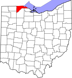
Lucas County is in northwest Ohio in the United States. Its county seat is Toledo.
Subcategories
This category has the following 3 subcategories, out of 3 total.
Media in category "Maps of Lucas County, Ohio"
The following 50 files are in this category, out of 50 total.
-
"Outline Plan of Lucas County, Ohio", 1888 - DPLA - c3e10c87b0e81f88c33f67cc7f460b19.jpg 3,099 × 2,085; 887 KB
-
1805 Survey - Twelve Mile Square Reserve.png 1,854 × 1,854; 1.16 MB
-
1827 Plat - Twelve Square Miles Reserve.jpg 3,500 × 4,656; 1.49 MB
-
Lucas County Ohio map by Riley, 1855.jpg 7,708 × 5,363; 7.58 MB
-
1875 Maumee Ohio map.jpg 3,508 × 2,280; 2 MB
-
1888 Map of Lucas and parts of Wood, Ottawa and Sandusky Counties, Ohio.jpg 17,370 × 11,606; 42.59 MB
-
OH Toledo 520140 1900 62500.jpg 2,482 × 3,051; 1.45 MB
-
History of the city of Toledo and Lucas County, Ohio (1888) (14578902557).jpg 3,040 × 2,036; 663 KB
-
Lucas County Ohio incorporated and unincorporated areas.svg 835 × 641; 4.16 MB
-
Lucas County, Ohio historical map, 1855 - DPLA - 1913f034ffdbed36b68de0bef9f393d6.jpg 9,000 × 6,261; 4.87 MB
-
Lucas County, Ohio historical map, 1899 - DPLA - 15d00f03bb083bbc2dfeccd83c293084.jpg 8,327 × 6,700; 2.52 MB
-
Lucas County, Ohio historical map, 1916 - DPLA - 878e19153d6041424cf12465612f1418.jpg 6,686 × 5,385; 2.45 MB
-
Lucas County, Ohio historical map, 1919 - DPLA - db17f8331d066c1ddba083f659dfd1ab.jpg 6,563 × 5,555; 1.89 MB
-
Lucas County, Ohio historical map, 1920 - DPLA - 81178860cfb7df5ec27eb1567e5672be.jpg 8,999 × 6,221; 3.36 MB
-
Lucas County, Ohio historical map, 1920 - DPLA - fe002355232dc436033feac95587c15f.jpg 9,000 × 5,640; 5.75 MB
-
Map of Lucas County, Ohio LOC 2012592375.jpg 21,887 × 14,043; 34.94 MB
-
Map of Lucas County, Ohio, 1861.jpg 15,868 × 15,646; 51.74 MB
-
Map of Lucas County, Ohio, 1896.jpg 21,887 × 14,043; 54.83 MB
-
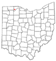
Map of Ohio highlighting Lucas County.svg 1,050 × 1,141; 37 KB
-
Maumee Road Lands.png 936 × 543; 372 KB
-
Ohimage.PNG 793 × 534; 164 KB
-
OHMap-doton-Berkey.png 274 × 300; 10 KB
-
OHMap-doton-Curtice.png 309 × 352; 17 KB
-
OHMap-doton-Harbor View.png 274 × 300; 10 KB
-
OHMap-doton-Holland.png 274 × 300; 10 KB
-
OHMap-doton-Maumee.png 274 × 300; 10 KB
-
OHMap-doton-Monclova.png 309 × 352; 17 KB
-
OHMap-doton-Neapolis.png 309 × 352; 17 KB
-
OHMap-doton-Ottawa Hills.png 274 × 300; 10 KB
-
OHMap-doton-Providence.png 309 × 352; 17 KB
-
OHMap-doton-Swanton.png 274 × 300; 10 KB
-
OHMap-doton-Sylvania.png 274 × 300; 10 KB
-
OHMap-doton-Waterville.png 274 × 300; 10 KB
-
OHMap-doton-Whitehouse.png 274 × 300; 10 KB
-
Ottawahillsplatmap.gif 800 × 715; 140 KB
-
West Sister Island Karte.png 2,000 × 1,789; 157 KB


