Category:Maps of Landkreis Rosenheim
Jump to navigation
Jump to search
Urban districts (cities): Amberg · Ansbach · Aschaffenburg · Augsburg · Bamberg · Bayreuth · Coburg · Erlangen · Fürth · Hof · Ingolstadt · Kaufbeuren · Kempten · Landshut · Memmingen · Munich · Nuremberg · Passau · Regensburg · Rosenheim · Schweinfurt · Straubing · Weiden in der Oberpfalz · Würzburg
Deutsch: Karten und Pläne des Landkreises Rosenheim.
Wikimedia category | |||||
| Upload media | |||||
| Instance of | |||||
|---|---|---|---|---|---|
| Category combines topics | |||||
| Rosenheim | |||||
district of Bavaria, Germany    .svg) | |||||
| Instance of |
| ||||
| Location | Upper Bavaria, Bavaria, Germany | ||||
| Capital | |||||
| Head of government |
| ||||
| Inception |
| ||||
| Highest point | |||||
| Population |
| ||||
| Area |
| ||||
| Elevation above sea level |
| ||||
| Different from | |||||
| official website | |||||
 | |||||
Subcategories
This category has only the following subcategory.
Media in category "Maps of Landkreis Rosenheim"
The following 21 files are in this category, out of 21 total.
-
 Bayern landkreis rosenheim karte.png 237 × 245; 15 KB
-
 Chiemsee Karte Moränen Vergangenheit Zukunft (retuschiert).jpg 1,880 × 2,016; 2.2 MB
-
 Chiemsee Karte Moränen Vergangenheit Zukunft b.jpg 1,851 × 1,976; 1.36 MB
-
 Chiemsee Karte Moränen Vergangenheit Zukunft retusche.jpg 1,884 × 2,011; 3.09 MB
-
 Chiemsee Karte Moränen Vergangenheit Zukunft.jpg 1,977 × 2,203; 483 KB
-
 Chiemsee Karte Tiefen b.jpg 1,817 × 1,664; 624 KB
-
 Chiemsee Karte Tiefen retusche.jpg 1,853 × 1,711; 1.24 MB
-
 Chiemsee Karte Tiefen.jpg 1,959 × 1,893; 273 KB
-
 Der Chiemsee, als er bis Marquartstein reichte.jpg 832 × 736; 446 KB
-
 Der Chiemsee, etwa nach 2500 Jahren.jpg 832 × 736; 427 KB
-
 Der Chiemsee, etwa nach 5000 Jahren.jpg 832 × 736; 409 KB
-

-
 Lage des Landkreises Rosenheim in Deutschland.png 176 × 234; 5 KB
-
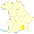
 Landkreis und Stadt Rosenheim mit Nachbarkreisen.svg 400 × 420; 38 KB
-
 Locator map RO in Bavaria.svg 867 × 855; 1,009 KB
-
 Locator map RO in Germany.svg 1,075 × 1,273; 581 KB
-
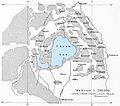
 Moränenkarte des Chiemseegebietes.jpg 833 × 736; 454 KB
-
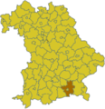
 RO (Lkr) in Bayern.svg 1,227 × 1,236; 311 KB
-
 Rott Karte.png 5,545 × 7,223; 34.1 MB
-
 Seen um Kufstein und Kiefersfelden.jpg 940 × 1,025; 438 KB
-
 Volksbank Raiffeisenbank Mangfalltal-Rosenheim Geschäftsgebiet.jpg 458 × 413; 81 KB

.jpg)


_Mattes_2023-04-22.jpg)


_in_Bayern.svg)


