Urban districts (cities):
<nowiki>Category:Maps of Jena; categoría de Wikimedia; kategori Wikimedia; Wikimedia category; د ويکيمېډيا وېشنيزه; Vikimedya kategorisi; ویکیمیڈیا زمرہ; kategória projektov Wikimedia; категорія проєкту Вікімедіа; 维基媒体分类; Wikimedia-Kategorie; kategorie na projektech Wikimedia; Wikimedia-Kategorie; विकिपीडिया:श्रेणी; page de catégorie de Wikimedia; kategorija na Wikimediji; विकिपीडिया वर्ग; категорија на Викимедији; Wikimedia-Kategorie; Wikimedia-kategori; kategori Wikimédia; تصنيف ويكيميديا; pajenn rummata eus Wikimedia; Wikimedia:ကဏ္ဍခွဲခြင်း; 維基媒體分類; Wikimedia категориясы; categoría de Wikimedia; Wikimedia-categorie; Wikimedia-Kategorie; tudalen categori Wikimedia; Viciméid catagóir; ردهٔ ویکیپدیا; 维基媒体分类; Wikimedia-kategory; ვიკიპედია:კატეგორიზაცია; ウィキメディアのカテゴリ; categoria Wikimedia; تصنيف بتاع ويكيميديا; විකිමීඩියා ප්රභේද පිටුව; categoria Vicimediorum; विकिमीडिया श्रेणी; Wikimedia-luokka; Wikimedia-categorie; guruhi Vikimedia; катэгорыя ў праекце Вікімэдыя; Викимедиа проектындагы төркем; catigurìa di nu pruggettu Wikimedia; หน้าหมวดหมู่วิกิมีเดีย; Wikimedia:Kategorija; Wikimedia-Kategorie; Wikimedia:Klassys; категория на Уикимедия; categorie a unui proiect Wikimedia; 維基媒體分類; Wikimedia-kategori; kawan Wikimèdia; гурӯҳи Викимедиа; 위키미디어 분류; Wikimedia-bólkur; kategorio en Vikimedio; kategori Wikimedia; categoría de Wikimedia; উইকিমিডিয়া বিষয়শ্রেণী; kategori Wikimedia; 维基媒体分类; וויקימעדיע קאַטעגאָריע; kategorija w projektach Wikimedije; thể loại Wikimedia; Wikimedia projekta kategorija; Wikimedia-kategorie; categoria de um projeto da Wikimedia; Wikimedia category; категорияд Ангилал; Wikimedia-kategori; kategori Wikimedia; پۆلی ویکیمیدیا; Wikimedia category; Vikimédia ñemohenda; Wikimédia-kategória; વિકિપીડિયા શ્રેણી; Wikimediako kategoria; категория в проекте Викимедиа; Wikimedia-Kategorie; Kategoriya ning Wikimedia; Wikimedia-kategorie; Wîkîmediya:Kategorî; विकिमिडिया श्रेणी; Wikimedia-Kategorie; קטגוריה במיזמי ויקימדיה; Викимедиа проектындагы төркем; Wikimedia-categorie; विकिमिडिया श्रेणी; κατηγορία εγχειρημάτων Wikimedia; Wikimedia-kategoriija; гурӯҳи Викимедиа; jamii ya Wikimedia; 維基媒體分類; Wikimedia:Ronnaghys; categoria di un progetto Wikimedia; Wikimedia-Kategorie; 维基媒体分类; categurìa 'e nu pruggette Wikimedia; Wikimedia kategooria; Wikimedia category; Wikimedia-kategori; kategorya ng Wikimedia; 維基媒體分類; ẹ̀ka Wikimedia; Викимедиина категорија; categoria de um projeto da Wikimedia; kategorija na Wikimediji; Վիքիմեդիայի նախագծի կատեգորիա; tumbung Wikimedia; kategoria ti Wikimedia; kategorija Wikimedie; Wikimedia proyektındağı törkem; categoria de Wikimedia; Викимедиа категорияһы; kategori Wikimedia; kategoria w projekcie Wikimedia; വിക്കിമീഡിയ വർഗ്ഗം; 維基媒體分類; kategori Wikimedia; விக்கிமீடியப் பகுப்பு; زمرو:وڪيپيڊيا زمرا بندي; Vikipidiya:Shopni; categoría de Wikimedia; kategori e Wikimedias; 维基媒体分类; катэгорыя ў праекце Вікімедыя</nowiki>
Subcategories
This category has the following 3 subcategories, out of 3 total.


 Bahnhöfe und Haltepunkte in Jena 2.png 492 × 590; 113 KB
 Bahnhöfe und Haltepunkte in Jena 3.png 492 × 590; 113 KB
 Bahnhöfe und Haltepunkte in Jena.png 492 × 590; 113 KB
 Jena 1999-01-10 05.jpg 696 × 532; 173 KB
 Jena in German Democratic Republic.svg 618 × 789; 3 MB
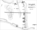 Jena-Lobeda, Johannisberg, Grabungsflaechen 1957 und 1959.png 2,140 × 1,762; 172 KB
 Jena-Lobeda, Johannisberg, Plan Sesselmann 1957.png 2,363 × 1,565; 1.35 MB
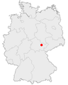 Jena-Position.png 140 × 175; 14 KB
 Karte des Deutschen Reiches (5820439).jpg 11,487 × 14,017; 65.01 MB
 Karte Muehlenradweg.png 1,000 × 471; 66 KB
 Location map J in Thuringia.svg 966 × 758; 622 KB
 Stadtplan Jena Tourist.jpg 2,796 × 2,333; 2.08 MB
 Stadtteilkarte Jena.png 891 × 1,110; 468 KB
 Thuringia districts J.svg 512 × 423; 30 KB
 Thuringia J.svg 966 × 758; 153 KB


.jpg)


