
Category:Maps of Europe in the 8th century
English: This category is about the subject of Europe 701-800 CE: History maps showing all or a substantial part of the territory of Europe as it was in the 8th century.
Contemporary old maps belong into: Category:Old maps of Europe and its subcategories.
Contemporary old maps belong into: Category:Old maps of Europe and its subcategories.
Maps of the history of Europe: (BCE) 9th century · 8th century · 5th century · 4th century · 3rd century · 2nd century · 1st century · (CE) 1st century · 2nd century · 3rd century · 4th century · 5th century · 6th century · 7th century · 8th century · 9th century · 10th century · 11th century · 12th century · 13th century · 14th century · 15th century · 16th century · 17th century · 18th century · 19th century · 20th century · 21st century ·
Subcategories
This category has the following 15 subcategories, out of 15 total.
B
F
G
I
S
W
Media in category "Maps of Europe in the 8th century"
The following 37 files are in this category, out of 37 total.
-
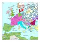
 C. 720 Europe.jpg 1,605 × 1,209; 936 KB
-
 C. 750 Eastern Patriarchates.jpg 3,996 × 3,096; 3.06 MB
-
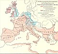
 768-814 Europe (Johnston).jpg 4,086 × 3,021; 3.23 MB
-

-
 Europe en 700.pdf 1,752 × 1,239; 586 KB
-
 Historical atlas of modern Europe 1903 (135895354).jpg 9,126 × 6,828; 52.5 MB
-
 737 CE, Europe.svg 512 × 438; 1.62 MB
-
 Europe en 750.pdf 1,752 × 1,239; 588 KB
-
 771 CE, Europe.svg 512 × 438; 1.62 MB
-

-
 Anatolia ca 740 AD-es.svg 925 × 480; 17.51 MB
-
 Ancient European Geography from Rees's Cyclopaedia.jpg 2,917 × 2,305; 2.61 MB
-
 Asia Minor ca 740 AD ZH.svg 1,317 × 687; 1.45 MB
-
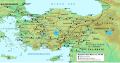
 Asia Minor ca 740 AD.svg 1,317 × 687; 2.32 MB
-
 Asia Minor ca 780 AD ZH.svg 1,317 × 687; 1.45 MB
-
 Asia Minor ca 780 AD-ar.svg 1,317 × 687; 2.19 MB
-
 Asia Minor ca 780 AD-es.svg 925 × 480; 17.57 MB
-
 Asia Minor ca 780 AD-pt.svg 1,317 × 687; 1.43 MB
-
 Asia Minor ca 780 AD.svg 1,317 × 687; 2.35 MB
-

-
 Byzantine Empire 814 - Shepherds.png 601 × 554; 734 KB
-
 Califate 750.jpg 1,492 × 1,248; 494 KB
-
 East Slavic tribes peoples 8th 9th century.jpg 767 × 952; 388 KB
-
 Europe Middle East 800 Colour.png 4,256 × 2,884; 3.11 MB
-
 Europe occidentale vers 720.gif 893 × 713; 446 KB
-
 Europe VII-e VIII-e siècles.jpg 10,902 × 7,080; 6.84 MB
-
 Frankish Empire 768 to 814-it.svg 1,735 × 1,343; 274 KB
-
 Kaukasus 750 map alt de.png 2,990 × 2,324; 3.63 MB
-
 Map of the Caucasus, 740 CE.svg 1,155 × 898; 4.39 MB
-
 North and south of the Pyrenees (Year 760).jpg 549 × 478; 92 KB
-

-
 Putz23.jpg 1,569 × 1,458; 234 KB
-
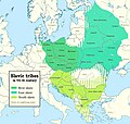 Slavic tribes in the 7th to 9th century.jpg 1,520 × 1,442; 647 KB
-
 Spruner-Menke Handatlas 1880 Karte 03.jpg 3,617 × 3,005; 1.13 MB
-
 Western European languages800AD.png 585 × 410; 47 KB
-
 Carte des pays Slavo-Polonais aux VIII et IX siecles 1861 (68530044).jpg 10,533 × 7,738; 14.52 MB
-
 Византийская Империя (717 г.).png 745 × 310; 127 KB


.jpg)
.jpg)
.jpg)


.jpg)


.jpg)


.jpg)


.jpg)
.png)