Category:Maps of Chesapeake & Ohio Canal National Historical Park
Jump to navigation
Jump to search
English: Maps of C&O Canal National Historical Park
Wikimedia category | |||||
| Upload media | |||||
| Instance of | |||||
|---|---|---|---|---|---|
| Category combines topics | |||||
| Chesapeake and Ohio Canal National Historical Park | |||||
National Historical Park located in the District of Columbia and the states of Maryland and West Virginia  Basin at the north end of the Chesapeake and Ohio Canal  | |||||
| Instance of | |||||
| Named after | |||||
| Location | |||||
| Located in or next to body of water | |||||
| Operator |
| ||||
| Maintained by |
| ||||
| Has part(s) |
| ||||
| Heritage designation |
| ||||
| IUCN protected areas category | |||||
| Inception |
| ||||
| Length |
| ||||
| Area |
| ||||
| Elevation above sea level |
| ||||
| Visitors per year |
| ||||
| official website | |||||
 | |||||
Subcategories
This category has the following 2 subcategories, out of 2 total.
Media in category "Maps of Chesapeake & Ohio Canal National Historical Park"
The following 47 files are in this category, out of 47 total.
-
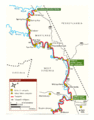
 Chesapeake and Ohio Canal National Historical Park (map).svg 1,003 × 2,514; 5.42 MB
-
 Chesapeake and Ohio Canal National Historical Park (map).jpg 2,740 × 7,248; 6.8 MB
-
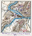 Attack on Harper's Ferrypass5.jpg 1,688 × 1,925; 2.69 MB
-
-

-

-

-

-

-

-
-

-

-

-
-

-

-

-

-

-

-

-

-

-

-

-

-
 GF-Map-Page-2 (cropped).jpg 2,730 × 2,467; 489 KB
-
 GF-Map-Page-2.pdf 2,456 × 1,725; 1.04 MB
-

-
 NPS co-canal-billy-goat-trail-geologic-map.jpg 1,869 × 2,214; 724 KB
-
 NPS co-canal-great-falls-trail-map.jpg 2,293 × 1,476; 312 KB
-
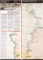
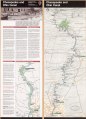
 NPS co-canal-map.jpg 1,712 × 4,388; 1.25 MB
-
 NPS co-canal-map.pdf 2,066 × 4,133; 4.48 MB
-
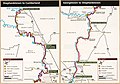
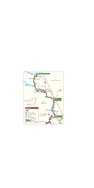
 NPS co-canal-north-simple-map.gif 1,601 × 2,043; 169 KB
-
 NPS co-canal-north-simple-map.pdf 2,002 × 2,554; 132 KB
-
 NPS co-canal-south-simple-map.gif 1,618 × 2,048; 165 KB
-
 NPS co-canal-south-simple-map.pdf 2,022 × 2,560; 124 KB
-
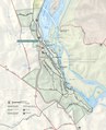
 NPS great-falls-map.jpg 1,974 × 2,426; 683 KB
-
 NPS great-falls-map.pdf 1,285 × 1,581; 4.98 MB
-
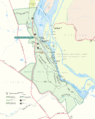 NPS great-falls-park-map.gif 1,937 × 2,435; 437 KB
-
 NPS great-falls-park-map.pdf 1,262 × 1,587; 4.81 MB
-
 NPS great-falls-regional-map.gif 1,002 × 829; 81 KB
-
 NPS great-falls-regional-map.pdf 347 × 287; 291 KB
-
 NPS potomac-gorge-map.jpg 1,686 × 1,422; 513 KB
-
 NPS potomac-river-gorge-map.gif 1,296 × 2,719; 322 KB
-
 NPS potomac-river-gorge-map.pdf 843 × 1,772; 220 KB


.jpg)


.svg)
.jpg)