Category:Maps of Bournemouth, Christchurch and Poole
Jump to navigation
Jump to search
English: Maps of the Bournemouth, Christchurch and Poole district, in the ceremonial county of Dorset, England.
Subcategories
This category has the following 5 subcategories, out of 5 total.
- Maps of the Borough of Poole (9 F)
B
- Maps of Bournemouth (28 F)
Media in category "Maps of Bournemouth, Christchurch and Poole"
The following 6 files are in this category, out of 6 total.
-

-
 BOURNEMOUTH, CHRISTCHURCH AND POOLE (49910743231).png 2,160 × 1,080; 320 KB
-
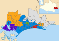 Bournemouth, Christchurch and Poole UK 2019.svg 1,154 × 796; 1.7 MB
-
 Bournemouth, Christchurch and Poole UK 2023.svg 1,154 × 796; 1.69 MB
-
 Bournemouth, Christchurch and Poole UK locator map.png 800 × 556; 61 KB
-
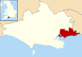 Bournemouth, Christchurch and Poole UK locator map.svg 1,425 × 990; 753 KB
%27_(11202628565).jpg)
.png)


