Category:Maps of Banat of Temeswar
Jump to navigation
Jump to search
Media in category "Maps of Banat of Temeswar"
The following 29 files are in this category, out of 29 total.
-
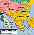 AtlBalk1750.jpg 318 × 327; 179 KB
-
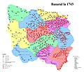 Banatul la 1743.jpg 2,526 × 2,168; 2.45 MB
-
 Banatul la 1774.jpg 2,526 × 2,168; 2.83 MB
-

-
 Habsburg Serbia.JPG 439 × 1,047; 101 KB
-
 Josephinische Landaufnahme Banat.jpg 1,446 × 1,778; 346 KB
-
 Map of Banat of Temeswar by Castulus Riedl.jpg 8,550 × 9,876; 14.2 MB
-
 Map of Central Europe in 1791 by Reilly 006.jpg 650 × 508; 104 KB
-
 Map of Central Europe in 1791 by Reilly 006b.jpg 1,200 × 906; 273 KB
-
 Nova Barselona Banat .jpg 3,247 × 2,433; 5.36 MB
-
 Passarowitz 1718.JPG 1,200 × 1,681; 977 KB
-
 Serbia1718 1739-sr.png 851 × 737; 73 KB
-
 Serbia1718 1739.png 851 × 737; 71 KB
-
 Tamis banat1718 1739 hu.png 1,178 × 1,514; 423 KB
-
 Tamis banat1718 1739.png 1,008 × 1,298; 146 KB
-
 Tamis banat1718 1739 sr.png 1,008 × 1,298; 134 KB
-
 Banat03-sr.png 998 × 876; 85 KB
-
 Banat03.png 998 × 876; 102 KB
-
 Temeswarer Banat - Politische Situation 1739.png 998 × 876; 98 KB
-
 Tamis banat06-sr.png 996 × 988; 100 KB
-
 Tamis banat06.png 996 × 988; 111 KB
-
 Tamis banat1751 1778-sr.png 996 × 962; 98 KB
-
 Tamis banat1751 1778.png 996 × 962; 112 KB
-
 Temeswarer Banat - Politische Situation 1751 -1778.png 996 × 962; 108 KB
-
 Temescher Banat BV044698769.jpg 9,164 × 6,841; 12.09 MB
-
 Temesi bánság és környéke az 1716-1717 Claude Florimond de Mercy térképe.jpg 2,048 × 1,736; 5.55 MB
-
 Temeswarer Banat.JPG 2,406 × 2,745; 1.69 MB
-
 Temisvarski sabor 1790 01.png 996 × 704; 84 KB
-
 Temisvarski sabor 1790 02.png 996 × 704; 69 KB


Categories:
- Banat of Temeswar
- Kingdom of Serbia (1718–1739)
- Treaty of Passarowitz
- Maps of the history of Early Modern Romania
- Maps of the Ottoman period in the history of Serbia
- Maps of the Habsburg period in the history of Serbia
- Maps of the history of Vojvodina
- Maps of the history of Banat
- Maps of the history of Bačka
- Maps of the history of Syrmia
- Maps of the Habsburg Monarchy