Category:Maps of Amur River
Jump to navigation
Jump to search
Media in category "Maps of Amur River"
The following 40 files are in this category, out of 40 total.
-
 Der Jesuiten-Atlas der Kanghsi-Zeit - China und die Aussenlaender LOC 74650033-3.jpg 8,152 × 7,868; 7.49 MB
-
 Der Jesuiten-Atlas der Kanghsi-Zeit - China und die Aussenlaender LOC 74650033-3.tif 8,152 × 7,868; 183.51 MB
-
 Der Jesuiten-Atlas der Kanghsi-Zeit - China und die Aussenlaender LOC 74650033-4.jpg 10,677 × 9,515; 11.37 MB
-
 Der Jesuiten-Atlas der Kanghsi-Zeit - China und die Aussenlaender LOC 74650033-4.tif 10,677 × 9,515; 290.66 MB
-
 Der Jesuiten-Atlas der Kanghsi-Zeit - China und die Aussenlaender LOC 74650033-5.tif 5,835 × 9,690; 161.77 MB
-
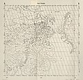
 Illustrated general route map of three countries (14590511136).jpg 2,500 × 1,764; 1.2 MB
-
 Nan bei yang he tu. LOC gm71005215.jpg 5,106 × 7,122; 4.64 MB
-
 Nan bei yang he tu. LOC gm71005215.tif 5,106 × 7,122; 104.04 MB
-
 Huang chao zhi sheng di yu quan tu - btv1b531099218 (27 of 38).jpg 4,548 × 3,184; 2.01 MB
-
 1903-Syberia-Amur.jpg 2,833 × 1,888; 1.17 MB
-
 59 of 'China in Transformation ... With ... maps and diagrams' (11247294074).jpg 1,423 × 1,541; 636 KB
-

-
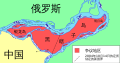
 Amur hu.svg 1,861 × 1,278; 458 KB
-
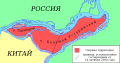
 Amur mk.svg 1,861 × 1,278; 931 KB
-
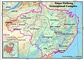
 Amur-ecoregion-map.jpg 1,920 × 1,358; 977 KB
-
 Amur-en.svg 1,861 × 1,278; 447 KB
-
 Amur.svg 1,861 × 1,278; 462 KB
-
 Battle of the Amur River 1945.png 1,056 × 695; 384 KB
-
 Bolshoy Ussuriysky and Tarabarov AZ.svg 2,453 × 1,280; 487 KB
-
 Bolshoy Ussuriysky and Tarabarov EN.svg 2,453 × 1,280; 487 KB
-
 Bolshoy Ussuriysky and Tarabarov MK.svg 2,453 × 1,280; 396 KB
-
 Bolshoy Ussuriysky and Tarabarov RU.svg 2,453 × 1,280; 428 KB
-
 Bolshoy Ussuriysky and Tarabarov ZH.svg 2,453 × 1,280; 365 KB
-

-
 Firing upon the Russian Men-of-War in Amur River.jpg 5,981 × 3,600; 2.02 MB
-
 Fuyu territory.png 480 × 390; 222 KB
-
 Le Tour du monde-01-p100.jpg 1,219 × 810; 325 KB
-
 Map of Amur-Heilong Ecoregion.jpg 967 × 682; 140 KB
-
 Map of Karafuto and the Amur estuary by Mamiya Rinzo (1810)/間宮林蔵『黒竜江中州并天度』(文化7年).jpg 8,000 × 3,968; 25.71 MB
-
 Map of the Amur−Heilongjiang region.jpg 423 × 611; 64 KB
-
 Reisen und forschungen im Amur-lande in den jahren 1854-1856 (1859) (14751402182).jpg 3,458 × 2,641; 2.05 MB
-
 Russian Empire 1745 (Map XIX HQ).jpg 9,048 × 8,254; 8.85 MB
-
 Russian Empire 1745 (Map XIX in Latin).jpg 7,504 × 6,859; 14.69 MB
-
 Russian Empire 1745 (Map XIX).jpg 2,172 × 1,968; 2.56 MB
-
 Russian Empire 1745 (Map XVII HQ).jpg 8,999 × 8,245; 10 MB
-
 Russian Empire 1745 (Map XVII).jpg 2,184 × 1,959; 3.06 MB
-
 Russian Forts On The Far East 1850-1853.jpg 798 × 1,128; 260 KB
-
 Zhenbao island.png 1,200 × 1,064; 353 KB
-
 Амур-ріка.jpg 1,024 × 714; 478 KB
-
 黑龍江口圖 - btv1b55000261c (1 of 2).jpg 6,399 × 5,987; 3.58 MB


.jpg)

.jpg)

.jpg)


%EF%BC%8F%E9%96%93%E5%AE%AE%E6%9E%97%E8%94%B5%E3%80%8E%E9%BB%92%E7%AB%9C%E6%B1%9F%E4%B8%AD%E5%B7%9E%E5%B9%B6%E5%A4%A9%E5%BA%A6%E3%80%8F%EF%BC%88%E6%96%87%E5%8C%967%E5%B9%B4%EF%BC%89.jpg)

_(14751402182).jpg)
.jpg)
.jpg)
.jpg)
.jpg)
.jpg)


.jpg)
.jpg)