Category:Map of the German Empire by Louis Stanislas d'Arcy de La Rochette
Jump to navigation
Jump to search
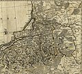
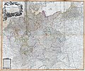
English: Map of the Empire of Germany, including the Kingdom of Prussia, and Austria. Was issued in various editions from the 1770s into th 1790s.
Cartographer: Louis Stanislas d'Arcy de La Rochette.
Engraver: Thomas Kitchin Sr.
Publisher: Robert Sayer, no. 53, Fleet-Street.
Prime meridian: Ferro.
Relief shown pictorially, ornamental title cartouche, the whole being an improvement of the maps of D'Anville and Robert.
Cartographer: Louis Stanislas d'Arcy de La Rochette.
Engraver: Thomas Kitchin Sr.
Publisher: Robert Sayer, no. 53, Fleet-Street.
Prime meridian: Ferro.
Relief shown pictorially, ornamental title cartouche, the whole being an improvement of the maps of D'Anville and Robert.
Media in category "Map of the German Empire by Louis Stanislas d'Arcy de La Rochette"
The following 16 files are in this category, out of 16 total.
-

-

-
 East Prussia and Lithuania map detail (Delarochette, 1782).jpg 2,574 × 2,314; 1.25 MB
-
 Figurative cartouche on a HRE map by Delarochette.jpg 2,592 × 2,524; 1.43 MB
-
 Map of the Empire of Germany (1782).tif 1,163 × 1,024; 3.41 MB
-
 Map of the Empire of Germany (Delarochette, 1782).jpg 10,500 × 9,240; 20.06 MB
-
 Map of the Empire of Germany (Delarochette, 1790).jpg 9,900 × 8,366; 20.43 MB
-
 Map of the Empire of Germany (Delarochette, 1794).jpg 9,311 × 7,847; 16.77 MB
-

-
 Map of the Empire of Germany, composite (Delarochette, 1790).jpg 10,300 × 8,704; 21.47 MB
-
 Map of the Empire of Germany, north side (Delarochette, 1790).jpg 14,664 × 6,378; 22.05 MB
-
 Map of the Empire of Germany, north side (Delarochette, 1794).jpg 14,614 × 6,381; 20.37 MB
-
 Map of the Empire of Germany, south side (Delarochette, 1790).jpg 14,650 × 6,363; 22.76 MB
-
 Map of the Empire of Germany, south side (Delarochette, 1794).jpg 14,698 × 6,429; 20.1 MB
-

-
 Scale cartouche on a HRE map by Delarochette.jpg 1,106 × 1,539; 312 KB


.jpg)

.jpg)
.jpg)
.jpg)
.jpg)
.jpg)
.jpg)
.jpg)
.jpg)
.jpg)

