Category:Map of Paris by Truschet and Hoyau
Jump to navigation
Jump to search
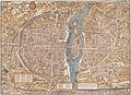
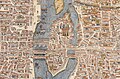
16th-century map of Paris  | |||||
| Upload media | |||||
| Instance of | |||||
|---|---|---|---|---|---|
| Depicts | Paris | ||||
| Point in time |
| ||||
| Inception |
| ||||
| Publication date |
| ||||
| Width |
| ||||
| Height |
| ||||
| |||||
Subcategories
This category has the following 2 subcategories, out of 2 total.
Media in category "Map of Paris by Truschet and Hoyau"
The following 13 files are in this category, out of 13 total.
-
 Plan de Paris vers 1550.jpg 4,028 × 2,900; 3.78 MB
-
 Atlas des anciens plans de Paris - 047. Paris en 1552 - David Rumsey.jpg 25,644 × 18,055; 148.56 MB
-
 Atlas des anciens plans de Paris - Paris en 1552 - BHVP.jpg 5,650 × 4,163; 8.56 MB
-
 Atlas des anciens plans de Paris - Paris en 1552 - David Rumsey.jpg 21,800 × 16,170; 240.76 MB
-
 Cardonetto28.11k.png 100 × 100; 8 KB
-
 La Ville, cité, université de Paris. Plan de Paris - Pl. 01 & 02 - BHVP.jpg 9,893 × 7,082; 54.31 MB
-
 Map of Paris by Truschet and Hoyau - Basel University Library.jpg 10,890 × 7,820; 93.39 MB
-

-
 Paris vers 1551 - plan de Truschet et Hoyau - Paris Musées.jpg 9,256 × 7,216; 41.94 MB
-
 Plan de Paris vers 1550 color.jpg 6,108 × 4,444; 23.18 MB
-
 Plano de París.jpg 1,280 × 843; 743 KB
-

-
 UBBasel Map 155u Kartenslg AA 124.tif 12,736 × 8,880, 2 pages; 323.59 MB


