
Category:Locator maps of cantons of Martinique
Administrative regions and territorial collectivity of Metropolitan France (‡ since start of 2016):
Auvergne-Rhône-Alpes‡ · Bourgogne-Franche-Comté‡ · Brittany · Centre-Val de Loire · Corsica · Grand Est‡ · Hauts-de-France‡ · Île-de-France · Normandy‡ · Nouvelle-Aquitaine‡ · Occitania‡ · Pays de la Loire · Provence-Alpes-Côte d'Azur
Overseas departments and regions: Guadeloupe · Martinique · French Guiana · Réunion · Mayotte
Departments of Metropolitan France: Ain [01] · Aisne [02] · Allier [03] · Alpes-de-Haute-Provence [04] · Hautes-Alpes [05] · Alpes-Maritimes [06] · Ardèche [07] · Ardennes [08] · Ariège [09] · Aube [10] · Aude [11] · Aveyron [12] · Bouches-du-Rhône [13] · Calvados [14] · Cantal [15] · Charente [16] · Charente-Maritime [17] · Cher [18] · Corrèze [19] · Corse-du-Sud [2A]† · Haute-Corse [2B]† · Côte-d’Or [21] · Côtes-d'Armor [22] · Creuse [23] · Dordogne [24] · Doubs [25] · Drôme [26] · Eure [27] · Eure-et-Loir [28] · Finistère [29] · Gard [30] · Haute-Garonne [31] · Gers [32] · Gironde [33] · Hérault [34] · Ille-et-Vilaine [35] · Indre [36] · Indre-et-Loire [37] · Isère [38] · Jura [39] · Landes [40] · Loir-et-Cher [41] · Loire [42] · Haute-Loire [43] · Loire-Atlantique [44] · Loiret [45] · Lot [46] · Lot-et-Garonne [47] · Lozère [48] · Maine-et-Loire [49] · Manche [50] · Marne [51] · Haute-Marne [52] · Mayenne [53] · Meurthe-et-Moselle [54] · Meuse [55] · Morbihan [56] · Moselle [57] · Nièvre [58] · Nord [59] · Oise [60] · Orne [61] · Pas-de-Calais [62] · Puy-de-Dôme [63] · Pyrénées-Atlantiques [64] · Hautes-Pyrénées [65] · Pyrénées-Orientales [66] · Bas-Rhin [67] · Haut-Rhin [68] · Haute-Saône [70] · Saône-et-Loire [71] · Sarthe [72] · Savoie [73] · Haute-Savoie [74] · Paris [75] · Seine-Maritime [76] · Seine-et-Marne [77] · Yvelines [78] · Deux-Sèvres [79] · Somme [80] · Tarn [81] · Tarn-et-Garonne [82] · Var [83] · Vaucluse [84] · Vendée [85] · Vienne [86] · Haute-Vienne [87] · Vosges [88] · Yonne [89] · Territoire de Belfort [90] · Essonne [91] · Hauts-de-Seine [92] · Seine-Saint-Denis [93] · Val-de-Marne [94] · Val-d'Oise [95]
Overseas departments and regions: Guadeloupe [971] · Martinique [972] · French Guiana [973] · Réunion [974] · Mayotte [976]
Overseas departments and regions: Guadeloupe [971] · Martinique [972] · French Guiana [973] · Réunion [974] · Mayotte [976]
Media in category "Locator maps of cantons of Martinique"
The following 54 files are in this category, out of 54 total.
-
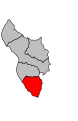
 Basse-Pointe 972.PNG 419 × 478; 15 KB
-
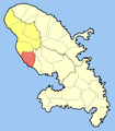 Canton Case-Pilote-Bellefontaine 972.PNG 419 × 478; 11 KB
-
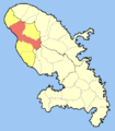
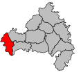
 Canton de Macouba 972.PNG 419 × 478; 14 KB
-
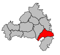
 Canton de Saint-Pierre 972.PNG 419 × 478; 13 KB
-
 Canton du Carbet 972.PNG 419 × 478; 13 KB
-
 Ducos 972.PNG 419 × 478; 15 KB
-
 Gros-Morne 972.PNG 419 × 478; 15 KB
-
 L-Ajoupa-Bouillon 972.PNG 419 × 478; 15 KB
-
 La Trinité 972.PNG 419 × 478; 15 KB
-
 Le Diamant 972.PNG 419 × 478; 15 KB
-
 Le Lorrain 972.PNG 419 × 478; 15 KB
-
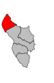
 Le Marigot 972.PNG 419 × 478; 15 KB
-
 Le Marin 972.PNG 419 × 478; 15 KB
-
 Le Morne-Rouge 972.PNG 419 × 478; 15 KB
-
 Le Precheur 972.PNG 419 × 478; 15 KB
-
 Le Vauclin 972.PNG 419 × 478; 15 KB
-
 Les Anses-d-Arlet 972.PNG 419 × 478; 15 KB
-
 Les Trois-Ilets 972.PNG 419 × 478; 15 KB
-
 Map canton code 97 201.svg 543 × 409; 8 KB
-
 Map canton code 97 202.svg 500 × 460; 10 KB
-
 Map canton code 97 203.svg 551 × 417; 8 KB
-
 Map canton code 97 204.svg 293 × 457; 4 KB
-
 Map canton code 97 205.svg 301 × 465; 4 KB
-
 Map canton code 97 206.svg 508 × 468; 10 KB
-
 Map canton code 97 207.svg 516 × 476; 10 KB
-
 Map canton code 97 215.svg 559 × 425; 8 KB
-
 Map canton code 97 217.svg 567 × 433; 8 KB
-
 Map canton code 97 218.svg 575 × 441; 8 KB
-
 Map canton code 97 219.svg 583 × 449; 8 KB
-
 Map canton code 97 220.svg 524 × 484; 10 KB
-
 Map canton code 97 221.svg 309 × 473; 4 KB
-
 Map canton code 97 223.svg 317 × 481; 4 KB
-
 Map canton code 97 224.svg 532 × 492; 10 KB
-
 Map canton code 97 225.svg 540 × 500; 10 KB
-
 Map canton code 97 227.svg 548 × 508; 10 KB
-
 Map canton code 97 228.svg 473 × 460; 5 KB
-
 Map canton code 97 229.svg 325 × 489; 4 KB
-
 Map canton code 97 230.svg 556 × 512; 10 KB
-
 Map canton code 97 231.svg 564 × 516; 10 KB
-
 Map canton code 97 234.svg 591 × 457; 8 KB
-
 Map canton code 97 235.svg 572 × 520; 10 KB
-
 Map canton code 97 236.svg 580 × 524; 10 KB
-
 Map canton code 97 294.svg 588 × 528; 10 KB
-
 Map canton code 97 295.svg 481 × 468; 5 KB
-
 Map canton code 97 296.svg 599 × 465; 8 KB
-
 Map canton code 97 297.svg 604 × 473; 8 KB
-
 Map canton code 97 298.svg 489 × 476; 5 KB
-
 Map canton code 97 299.svg 497 × 484; 5 KB
-
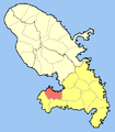
 Riviere-Pilote 972.PNG 419 × 478; 15 KB
-
 Riviere-Salee 972.PNG 419 × 478; 15 KB
-
 Saint-Esprit 972.PNG 419 × 478; 15 KB
-
 Saint-Joseph 972.PNG 419 × 478; 15 KB
-
 Sainte-Anne 972.PNG 419 × 478; 15 KB
-
 Sainte-Luce 972.PNG 419 × 478; 15 KB


