Category:Livingston (civil parish)
Jump to navigation
Jump to search
Scottish parish in West Lothian, Scotland, UK  | |||||
| Upload media | |||||
| Instance of | |||||
|---|---|---|---|---|---|
| Part of |
| ||||
| Named after |
| ||||
| Location |
| ||||
| Population |
| ||||
| Area |
| ||||
 | |||||
Subcategories
This category has the following 5 subcategories, out of 5 total.
B
D
L
S
Media in category "Livingston (civil parish)"
The following 200 files are in this category, out of 404 total.
(previous page) (next page)-
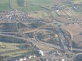 0702 Dechmont and Junction 3 of the M8 - geograph.org.uk - 1832398.jpg 1,024 × 768; 122 KB
-
 A705 looking westbound - geograph.org.uk - 2092209.jpg 640 × 480; 79 KB
-
 A705 no more - geograph.org.uk - 2092198.jpg 640 × 480; 93 KB
-
 A89 - geograph.org.uk - 4225525.jpg 800 × 600; 355 KB
-
 A89 Dechmont - geograph.org.uk - 2015208.jpg 640 × 480; 70 KB
-
 A89 towards Edinburgh - geograph.org.uk - 4597713.jpg 640 × 480; 64 KB
-
 A89 towards Edinburgh - geograph.org.uk - 4597732.jpg 640 × 480; 78 KB
-
 Alderstone Path - geograph.org.uk - 2673586.jpg 640 × 360; 261 KB
-
 Alderstone Path - geograph.org.uk - 2673603.jpg 640 × 360; 263 KB
-
 Alderstone Path - geograph.org.uk - 2683518.jpg 640 × 480; 347 KB
-
 Allen Road, Livingston - geograph.org.uk - 6163617.jpg 1,280 × 857; 837 KB
-

-

-
 Almond Valley Heritage Centre - geograph.org.uk - 2337109.jpg 419 × 640; 99 KB
-

-
 Almond View at Seafield - geograph.org.uk - 2605258.jpg 2,592 × 1,944; 1.81 MB
-
 Almond View, Seafield - geograph.org.uk - 2605263.jpg 2,592 × 1,944; 1.66 MB
-
 Almondvale at Livingston - geograph.org.uk - 5551508.jpg 3,264 × 2,448; 3.22 MB
-
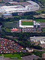 Almondvale Stadium from the air - geograph.org.uk - 3300962.jpg 480 × 640; 167 KB
-
 Almondvale Stadium from the air - geograph.org.uk - 3480024.jpg 640 × 480; 185 KB
-
 Almondvale Stadium from the air - geograph.org.uk - 5274410.jpg 640 × 480; 192 KB
-
 Almondvale, Livingston - geograph.org.uk - 3517334.jpg 3,264 × 2,448; 3.4 MB
-
 An Unexplained Pond - geograph.org.uk - 6838929.jpg 768 × 1,024; 248 KB
-
 Another old gravestone - geograph.org.uk - 1847784.jpg 2,048 × 1,536; 829 KB
-
 Apartments, Deer Park - geograph.org.uk - 1979627.jpg 640 × 480; 71 KB
-
 B792 Blackburn Road - geograph.org.uk - 2300618.jpg 640 × 480; 48 KB
-
 Back greens, Blackburn - geograph.org.uk - 2304739.jpg 640 × 480; 211 KB
-
 Banana warehouse at Deans - geograph.org.uk - 4315755.jpg 3,264 × 2,448; 4.35 MB
-
 Bangour Hospital, from above Livingston - geograph.org.uk - 2714280.jpg 3,264 × 2,448; 2.81 MB
-
 Bangour Village Hospital - geograph.org.uk - 3562433.jpg 640 × 302; 124 KB
-
 Barclay Way - geograph.org.uk - 5651726.jpg 640 × 300; 134 KB
-
 Barclay Way - geograph.org.uk - 5651728.jpg 640 × 407; 110 KB
-
 Beecraigs and Linlithgow - geograph.org.uk - 4345806.jpg 3,264 × 2,448; 3.77 MB
-
 Blackburn and Bathgate from the air - geograph.org.uk - 6391100.jpg 1,024 × 768; 314 KB
-
 Blackburn and Seafield Parish Church - geograph.org.uk - 4489815.jpg 1,600 × 1,067; 537 KB
-
 Blackburn War Memorial - geograph.org.uk - 4489792.jpg 1,600 × 1,067; 556 KB
-
 Blocks of Flats - geograph.org.uk - 4914368.jpg 640 × 427; 353 KB
-
 Bloom House - geograph.org.uk - 4908514.jpg 640 × 480; 453 KB
-
 Bloom roundabout, Livingston - geograph.org.uk - 6164096.jpg 1,280 × 857; 904 KB
-
 Bloom Steading - geograph.org.uk - 4908517.jpg 640 × 427; 317 KB
-
 Boarded-up house at Nether Dechmont - geograph.org.uk - 4320575.jpg 3,264 × 2,448; 4.98 MB
-
 Breich Path - geograph.org.uk - 5651803.jpg 640 × 427; 353 KB
-
 Breich Water - geograph.org.uk - 5651851.jpg 640 × 427; 265 KB
-
 Breich Water from the air - geograph.org.uk - 3300991.jpg 640 × 480; 137 KB
-
 Breich Way - geograph.org.uk - 5651797.jpg 640 × 427; 326 KB
-
 Bridge over the Almond - geograph.org.uk - 2050845.jpg 640 × 480; 120 KB
-
 Bridge over the Almond - geograph.org.uk - 2064642.jpg 640 × 480; 155 KB
-
 Bridge over the Almond - geograph.org.uk - 2064652.jpg 640 × 480; 104 KB
-
 Bridge over the River Almond - geograph.org.uk - 4475350.jpg 3,264 × 2,448; 6.24 MB
-
 Brightly Coloured Flats - geograph.org.uk - 5651705.jpg 640 × 481; 144 KB
-
 Broomyknowe Strip - geograph.org.uk - 4906316.jpg 3,264 × 2,448; 4.08 MB
-
 Buchanan Gardens, Livingston - geograph.org.uk - 6163637.jpg 1,280 × 857; 792 KB
-
 Bullocks grazing - geograph.org.uk - 2092234.jpg 640 × 480; 74 KB
-
 Bus stop and shelter on the A89 - geograph.org.uk - 4597706.jpg 640 × 480; 74 KB
-
 Bus stop and shelter on the A89 - geograph.org.uk - 4597707.jpg 640 × 480; 68 KB
-
 Bus stop and shelter on the A89 - geograph.org.uk - 4597716.jpg 640 × 480; 63 KB
-
 Bus stop and shelter on the A89 - geograph.org.uk - 4597731.jpg 640 × 480; 120 KB
-
 Camps Riggs - geograph.org.uk - 5651731.jpg 640 × 388; 140 KB
-
 Car park at Livingston North Station - geograph.org.uk - 4315923.jpg 3,264 × 2,448; 2.65 MB
-
 Carmondean Community Education Centre - geograph.org.uk - 4320609.jpg 3,264 × 2,448; 3.94 MB
-
 Central Livingston from the air - geograph.org.uk - 6269215.jpg 1,024 × 768; 467 KB
-
 Chuckethall Road - geograph.org.uk - 4914347.jpg 640 × 427; 388 KB
-
 Chuckethall Road - geograph.org.uk - 4914349.jpg 640 × 427; 259 KB
-
 City Farm - geograph.org.uk - 2993224.jpg 640 × 547; 84 KB
-
 Community Centre - geograph.org.uk - 4914362.jpg 640 × 427; 269 KB
-
 Compensation pond - geograph.org.uk - 2685533.jpg 640 × 480; 247 KB
-
 Condemned Buildings - geograph.org.uk - 4914372.jpg 640 × 427; 264 KB
-
 Cousland Crescent and Dean Place - geograph.org.uk - 2605267.jpg 2,592 × 1,944; 1.64 MB
-
 Cousland Farm - geograph.org.uk - 2092207.jpg 640 × 480; 69 KB
-
 Cousland Wood - geograph.org.uk - 5651745.jpg 640 × 427; 257 KB
-
 Covered reservoir at Deans - geograph.org.uk - 4320508.jpg 3,260 × 2,162; 2.09 MB
-
 Cul de sac, Ladywell - geograph.org.uk - 1980051.jpg 640 × 480; 72 KB
-
 Cul-de-sac at Deans - geograph.org.uk - 4320551.jpg 3,127 × 2,159; 2.69 MB
-
 Cycle path beside the A89 - geograph.org.uk - 4566284.jpg 640 × 480; 57 KB
-
 Deanburn Gardens - geograph.org.uk - 2605329.jpg 2,592 × 1,944; 2.04 MB
-
 Deanburn Gardens - geograph.org.uk - 5651767.jpg 640 × 388; 128 KB
-
 Deanburn Gardens, Seafield - geograph.org.uk - 2605334.jpg 2,592 × 1,944; 2.33 MB
-
 Deans Community High School, Livingston - geograph.org.uk - 4906326.jpg 3,264 × 2,448; 4.07 MB
-
 Deans North Road - geograph.org.uk - 3720896.jpg 640 × 480; 335 KB
-
 Deans Primary School - geograph.org.uk - 4914380.jpg 640 × 480; 348 KB
-
 Dechmont - geograph.org.uk - 4140670.jpg 640 × 480; 211 KB
-
 Dechmont and Houston Mains - geograph.org.uk - 4345811.jpg 3,264 × 2,448; 3.95 MB
-
 Dechmont Infant School - geograph.org.uk - 4597738.jpg 640 × 480; 54 KB
-
 Dechmont Main Street - geograph.org.uk - 3345288.jpg 640 × 427; 349 KB
-
 Dechmont post office - geograph.org.uk - 4502137.jpg 640 × 480; 272 KB
-
 Dechmont Post Office ^ General Store - geograph.org.uk - 4566290.jpg 640 × 480; 85 KB
-
 Deer park and the M8 from the air - geograph.org.uk - 2230755.jpg 2,592 × 1,944; 2.65 MB
-
 Deer Park golf course - geograph.org.uk - 1979594.jpg 640 × 480; 87 KB
-
 Deer Park golf course - geograph.org.uk - 3738968.jpg 640 × 480; 255 KB
-
 Development site, For Sale - geograph.org.uk - 2015154.jpg 640 × 480; 59 KB
-
 Dual use path beside the A89 - geograph.org.uk - 4597710.jpg 640 × 480; 90 KB
-
 Dual use path beside the A89 - geograph.org.uk - 4597717.jpg 640 × 480; 64 KB
-
 Dual use path beside the A89 - geograph.org.uk - 4597728.jpg 640 × 480; 57 KB
-
 Eastbound M8 approaching Junction 3 - geograph.org.uk - 6516916.jpg 800 × 533; 213 KB
-
 Easter Inch Moss information board - geograph.org.uk - 5895497.jpg 3,021 × 2,120; 2.09 MB
-
 Easter Inch Moss, Blackburn - geograph.org.uk - 5895499.jpg 3,264 × 2,448; 5.23 MB
-
 Edinburgh-Airdrie railway from the Moss Road bridge - geograph.org.uk - 2447702.jpg 2,592 × 1,944; 3.23 MB
-
 Edinburgh-Bathgate line - geograph.org.uk - 1979578.jpg 640 × 480; 76 KB
-
 Eliburn Campus Path - geograph.org.uk - 1807935.jpg 1,024 × 768; 154 KB
-
 Eliburn Park - geograph.org.uk - 1979720.jpg 640 × 480; 71 KB
-
 Eliburn Reservoir (2) - geograph.org.uk - 1979933.jpg 640 × 480; 79 KB
-
 Eliburn Reservoir - geograph.org.uk - 1979924.jpg 640 × 480; 84 KB
-
 Eliburn Reservoir - geograph.org.uk - 3504884.jpg 640 × 480; 45 KB
-
 Eliburn Road - geograph.org.uk - 1980059.jpg 640 × 480; 84 KB
-
 Eliburn South - geograph.org.uk - 1980023.jpg 640 × 480; 86 KB
-
 End of the path - geograph.org.uk - 1979552.jpg 640 × 480; 122 KB
-
 Entering Dechmont - geograph.org.uk - 4597736.jpg 640 × 480; 67 KB
-
 Entrance road, Bangour Village Hospital - geograph.org.uk - 3832307.jpg 1,024 × 678; 309 KB
-
 Entrance to Eliburn Park - geograph.org.uk - 4315763.jpg 3,264 × 2,448; 4.06 MB
-
 Entrance to Freeport - geograph.org.uk - 4474999.jpg 3,264 × 2,448; 4.68 MB
-
 Entrance to Livingston Crematorium - geograph.org.uk - 2092201.jpg 640 × 480; 78 KB
-
 Eroded Gravestones - geograph.org.uk - 4908541.jpg 640 × 640; 575 KB
-
 Estate Department building, Bangour Hospital - geograph.org.uk - 3832319.jpg 1,024 × 678; 194 KB
-
 Farm track, Cousland - geograph.org.uk - 2043043.jpg 640 × 480; 101 KB
-
 Field at City Farm - geograph.org.uk - 5651849.jpg 640 × 427; 161 KB
-
 Field at Seafield - geograph.org.uk - 5651775.jpg 640 × 427; 208 KB
-
 Field at Wester Breich - geograph.org.uk - 4475239.jpg 3,264 × 2,448; 4.69 MB
-
 Field boundary - geograph.org.uk - 2092229.jpg 640 × 480; 91 KB
-
 Field Entrance - geograph.org.uk - 5652009.jpg 640 × 427; 187 KB
-
 Fintry Avenue, Livingston - geograph.org.uk - 2477947.jpg 640 × 480; 62 KB
-
 Five Sisters - geograph.org.uk - 4099923.jpg 640 × 480; 257 KB
-
 Five Sisters Bing - geograph.org.uk - 5552770.jpg 640 × 427; 368 KB
-
 Five Sisters bing from the air - geograph.org.uk - 3434942.jpg 640 × 480; 133 KB
-
 Five Sisters Bing from the air - geograph.org.uk - 3435233.jpg 640 × 480; 130 KB
-
 Five Sisters bing from the air - geograph.org.uk - 3435242.jpg 640 × 480; 136 KB
-
 Five Sisters Bing from the air - geograph.org.uk - 3479981.jpg 640 × 480; 165 KB
-
 Five Sisters Bing from the air - geograph.org.uk - 3479990.jpg 640 × 480; 157 KB
-
 Five Sisters Bing from the air - geograph.org.uk - 6157854.jpg 1,024 × 768; 451 KB
-
 Five Sisters Bing from the air - geograph.org.uk - 6157855.jpg 1,024 × 768; 457 KB
-

-
 Five Sisters Business Park - geograph.org.uk - 2993218.jpg 640 × 480; 88 KB
-
 Five Sisters Business Park - geograph.org.uk - 6810189.jpg 2,752 × 3,309; 2.54 MB
-
 Flats in Quarrywood Court - geograph.org.uk - 6164107.jpg 1,280 × 857; 939 KB
-
 Flood in Deans South - geograph.org.uk - 4914382.jpg 480 × 640; 327 KB
-

-
 Footbridge - F85 - over the M8 - geograph.org.uk - 3341068.jpg 640 × 432; 33 KB
-
 Footbridge F85 - geograph.org.uk - 3645143.jpg 3,264 × 2,448; 2.55 MB
-

-

-
 Footbridge, Breich Water - geograph.org.uk - 2092223.jpg 640 × 480; 98 KB
-
 Footpath and subway - geograph.org.uk - 6164114.jpg 1,280 × 857; 1.58 MB
-
 Footpath at Woodlands Park - geograph.org.uk - 4320539.jpg 3,264 × 2,448; 3.64 MB
-

-
 Footpath signpost south of Seafield - geograph.org.uk - 4489923.jpg 1,600 × 1,067; 453 KB
-
 Ford, River Almond - geograph.org.uk - 2092219.jpg 640 × 480; 97 KB
-
 Former Bangour Village Hospital - geograph.org.uk - 6640768.jpg 1,024 × 432; 169 KB
-
 Former Redhouse School - geograph.org.uk - 2300685.jpg 640 × 480; 51 KB
-
 Freeport - geograph.org.uk - 4099928.jpg 640 × 480; 244 KB
-
 Freeport Retail Village - geograph.org.uk - 2675098.jpg 640 × 480; 258 KB
-
 Freeport Village - geograph.org.uk - 4474989.jpg 3,264 × 2,448; 2.69 MB
-
 Freeport Village from the air - geograph.org.uk - 4050819.jpg 640 × 480; 129 KB
-
 Freeport Village from the air - geograph.org.uk - 6157842.jpg 1,024 × 768; 445 KB
-
 Frozen Track - geograph.org.uk - 5651999.jpg 480 × 640; 303 KB
-
 Fusion Provida - geograph.org.uk - 4914321.jpg 640 × 318; 214 KB
-
 Gallacher Green - geograph.org.uk - 1979604.jpg 640 × 480; 64 KB
-
 Geddes House, Livingston - geograph.org.uk - 6163645.jpg 1,280 × 857; 891 KB
-
 Gospel Hall - geograph.org.uk - 4914377.jpg 640 × 427; 308 KB
-
 Grangemouth Refinery and harbour - geograph.org.uk - 4345800.jpg 3,264 × 2,448; 4.09 MB
-
 Grass showing through stubble - geograph.org.uk - 2092215.jpg 640 × 480; 74 KB
-
 Hanover Court - geograph.org.uk - 4908500.jpg 640 × 427; 339 KB
-
 Happy Valley Road - geograph.org.uk - 5651783.jpg 640 × 427; 136 KB
-
 Hardie Road - geograph.org.uk - 6592350.jpg 640 × 360; 65 KB
-
 Hawk Brae at Ladywell West - geograph.org.uk - 2447665.jpg 2,592 × 1,944; 2.01 MB
-
 Hawk Brae Livingston - geograph.org.uk - 1980046.jpg 640 × 480; 71 KB
-
 Heatherwood - geograph.org.uk - 2092324.jpg 640 × 480; 66 KB
-
 Hedgerow trees at Wester Breich - geograph.org.uk - 4475265.jpg 3,264 × 2,448; 4.75 MB
-
 Heritage Centre, Livingston - geograph.org.uk - 2020687.jpg 426 × 640; 260 KB
-
 Hospital car park - geograph.org.uk - 6513065.jpg 1,280 × 960; 872 KB
-
 Houses at Raeburn Rigg - geograph.org.uk - 4320594.jpg 3,264 × 2,448; 4.14 MB
-
 Houses on Main Street, Dechmont - geograph.org.uk - 4567069.jpg 640 × 480; 63 KB
-
 Houses, Knightsridge, Livingston - geograph.org.uk - 4570086.jpg 640 × 371; 45 KB
-
 Houses, Livingston - geograph.org.uk - 4570090.jpg 640 × 392; 75 KB
-
 Houses, Wester Dechmont - geograph.org.uk - 4566286.jpg 640 × 480; 65 KB
-
 Icy Puddles - geograph.org.uk - 5651772.jpg 640 × 427; 218 KB
-
 Is it a Footpath^ - geograph.org.uk - 5652021.jpg 480 × 640; 369 KB
-
 Junction Main Street-A89 - geograph.org.uk - 2015180.jpg 640 × 480; 67 KB
-
 Killandean Bridge - geograph.org.uk - 4908537.jpg 640 × 480; 515 KB
-
 Kirkton Campus from the air - geograph.org.uk - 3480003.jpg 640 × 480; 178 KB
-
 Kirkton Road North - geograph.org.uk - 4908508.jpg 640 × 427; 255 KB
-
 Knightsridge from the air - geograph.org.uk - 4901082.jpg 3,264 × 2,448; 3.7 MB
-
 Knightsridge West Road - geograph.org.uk - 3720886.jpg 640 × 480; 309 KB
-
 Knightsridge West Road - geograph.org.uk - 3725941.jpg 640 × 480; 249 KB
-
 Lanark Avenue, Livingston - geograph.org.uk - 3505156.jpg 640 × 480; 65 KB
-
 Land under cultivation (1) - geograph.org.uk - 2092278.jpg 640 × 480; 75 KB
-
 Land under cultivation (2) - geograph.org.uk - 2092283.jpg 640 × 480; 82 KB
-
 Leafy Tree by Lochshot Burn - geograph.org.uk - 6836184.jpg 1,024 × 768; 325 KB
-
 Livingston Crematorium - geograph.org.uk - 5651758.jpg 640 × 427; 125 KB
-
 Livingston from the air - geograph.org.uk - 3103943.jpg 640 × 480; 110 KB
-
 Livingston from the air - geograph.org.uk - 3558418.jpg 640 × 480; 168 KB
-
 Livingston from the air - geograph.org.uk - 5274413.jpg 640 × 480; 194 KB
-
 Livingston from the air - geograph.org.uk - 6157862.jpg 1,024 × 768; 471 KB
-
 Livingston Inn - geograph.org.uk - 4908495.jpg 640 × 427; 270 KB
-
 Livingston Letterbox - geograph.org.uk - 4908525.jpg 480 × 640; 476 KB
-
 Livingston Mill - geograph.org.uk - 2337894.jpg 422 × 640; 81 KB
-
 Livingston Mill - geograph.org.uk - 2337899.jpg 640 × 418; 76 KB
-
 Livingston Mill - geograph.org.uk - 2338711.jpg 640 × 416; 86 KB
-
 Livingston North car park - geograph.org.uk - 1979709.jpg 640 × 480; 71 KB
-
 Livingston North railway station - geograph.org.uk - 2228438.jpg 640 × 480; 146 KB
-
 Livingston North railway station - geograph.org.uk - 2228443.jpg 640 × 480; 148 KB
-
 Livingston North Railway Station - geograph.org.uk - 4568554.jpg 640 × 429; 68 KB


_-_geograph.org.uk_-_2092250.jpg)
_-_geograph.org.uk_-_2092259.jpg)


_-_geograph.org.uk_-_1979933.jpg)


_over_the_M8_near_Whitehill_Industrial_Estate_-_geograph.org.uk_-_6523074.jpg)


_-_geograph.org.uk_-_2092278.jpg)
_-_geograph.org.uk_-_2092283.jpg)


&filefrom=Livingston+North+railway+station%2C+West+Lothian+-+geograph.org.uk+-+3707656.jpg#mw-category-media)