Category:Liverpool to Manchester Lines
Jump to navigation
Jump to search
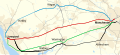
English: There are two Liverpool to Manchester railway lines between the cities of Liverpool and Manchester in the North West of England. The 'Northern Route' via Chat Moss to Manchester Piccadilly operates on lines formerly owned by the London and North Western Railway. The 'Southern Route' via Warrington Central to Manchester Piccadilly operates on lines formerly owned by the Cheshire Lines Committee
two railway lines between Liverpool and Manchester .jpg)  | |||||
| Upload media | |||||
| Instance of | |||||
|---|---|---|---|---|---|
| Part of |
| ||||
| Location |
| ||||
| Owned by | |||||
| Has part(s) |
| ||||
| |||||

Subcategories
This category has the following 48 subcategories, out of 48 total.
A
- Allerton Junction (8 F)
- Astley railway station (3 F)
B
- Birchwood railway station (12 F)
- Booker Avenue bridge (4 F)
C
- Chassen Road railway station (45 F)
D
- Deansgate railway station (79 F)
E
F
- Flixton railway station (8 F)
G
- Garfourth Road bridge (5 F)
- Glazebrook railway station (9 F)
- Greenhill Road bridge (9 F)
H
- Hough Green railway station (69 F)
I
- Irlam railway station (39 F)
J
L
M
N
P
- Padgate railway station (2 F)
- Patricroft railway station (58 F)
- Pendlebury railway station (3 F)
- Penny Lane bridge (9 F)
R
S
- Sankey railway station (4 F)
- Stalbridge Avenue bridge (5 F)
- Stephenson Way bridge (8 F)
T
U
- Urmston railway station (36 F)
W
- Widnes railway station (17 F)
- Woolton Road bridge (WJL3) (7 F)
Media in category "Liverpool to Manchester Lines"
The following 25 files are in this category, out of 25 total.
-
 Liverpool–Manchester lines.png 2,501 × 1,575; 3.39 MB
-

-

-

-
 Irlam Lancashire Steel Corporation plant 2021509 3cf0b8b1.jpg 640 × 449; 123 KB
-
 Irlam MMB 01 Manchester Ship Canal.jpg 3,852 × 1,953; 1.8 MB
-
 Irlam MMB 03 Manchester Ship Canal.jpg 3,711 × 1,983; 1.88 MB
-
 Liverpool Manchester railway crosses Bold Moss - geograph.org.uk - 2407101.jpg 1,600 × 1,074; 344 KB
-

-
 Liverpool to Manchester line from Prescot Road, Widnes.JPG 4,320 × 3,240; 4.85 MB
-
 Liverpool to Manchester Railway - geograph.org.uk - 2741488.jpg 640 × 418; 140 KB
-
 Manchester to Liverpool - geograph.org.uk - 58346.jpg 640 × 480; 96 KB
-
 Manchester to Liverpool rail track - geograph.org.uk - 1388370.jpg 640 × 480; 124 KB
-
 Manchester to Liverpool rail track - geograph.org.uk - 1388382.jpg 640 × 480; 124 KB
-

-
 Map of rail routes between Liverpool and Manchester in 1960.svg 702 × 318; 1.33 MB
-
 Railway crossing Glazebrook Moss - geograph.org.uk - 33238.jpg 640 × 480; 161 KB
-
 Railway east of Burtonwood Road, Hood Manor - geograph.org.uk - 4677502.jpg 1,024 × 768; 194 KB
-
 Railway Line towards Warrington - geograph.org.uk - 6207581.jpg 800 × 600; 901 KB
-
 Railway running east from Broseley Bridge - geograph.org.uk - 3355823.jpg 1,200 × 900; 295 KB
-
 Railway towards Liverpool - geograph.org.uk - 2866501.jpg 640 × 480; 99 KB
-
 Telecoms Pylon near Manchester - Liverpool Rail Line - geograph.org.uk - 2748057.jpg 3,000 × 4,000; 4.38 MB
-
 The Liverpool Manchester railway at Rainhill - geograph.org.uk - 2006471.jpg 1,600 × 1,198; 451 KB
-
 The Liverpool Manchester railway from Stoney Lane bridge - geograph.org.uk - 2042606.jpg 1,600 × 1,198; 481 KB
-
 View northwest from Greenhill Road bridge.jpg 5,152 × 3,864; 7.03 MB


.jpg)


