Category:Junction Lane bridge, Earlestown
Jump to navigation
Jump to search
| Object location | | View all coordinates using: OpenStreetMap |
|---|
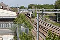
Now closed road bridge DSE/90 carrying Junction Lane (listed by Network Rail as Sugar Works Road) over the Liverpool to Manchester Lines to the west of Earlestown Railway Station. It is 14.64 miles from the datum at Liverpool Lime Street.
Media in category "Junction Lane bridge, Earlestown"
The following 8 files are in this category, out of 8 total.
-
 Junction Lane bridge, Earlestown 1.jpg 4,999 × 2,895; 18.21 MB
-
 Junction Lane bridge, Earlestown 2.jpg 5,146 × 3,406; 23.24 MB
-
 Junction Lane bridge, Earlestown 3.jpg 5,121 × 3,427; 21.03 MB
-
 Junction Lane bridge, Earlestown 4.jpg 5,114 × 3,338; 21.4 MB
-
 Junction Lane bridge, Earlestown 5.jpg 4,977 × 3,303; 21.25 MB
-
 Junction Lane bridge, Earlestown railway station (geograph 3818739).jpg 1,024 × 683; 179 KB
-
 Manchester to Liverpool Railway - geograph.org.uk - 1311979.jpg 640 × 480; 68 KB
-
 Platform 1, Earlestown railway station 3.jpg 5,183 × 3,440; 23.68 MB


.jpg)

