Category:Lanfranc Way bridge
Jump to navigation
Jump to search
| Object location | | View all coordinates using: OpenStreetMap |
|---|
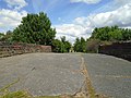
This bridge was used to connect farm fields; its width suggests it might have been intended to carry traffic, but that didn't happen and it has always been a footbridge.
Media in category "Lanfranc Way bridge"
The following 8 files are in this category, out of 8 total.
-
 Lanfranc Way bridge 1.jpg 4,926 × 3,696; 11.45 MB
-
 Lanfranc Way bridge 2.jpg 4,932 × 3,714; 9.64 MB
-
 Lanfranc Way bridge 3.jpg 5,123 × 3,810; 11.83 MB
-
 Lanfranc Way bridge 4.jpg 5,152 × 3,864; 7.45 MB
-
 Lanfranc Way bridge 5.jpg 3,864 × 5,152; 11.09 MB
-
 Lanfranc Way bridge 6.jpg 3,864 × 5,152; 10.45 MB
-
 Lanfranc Way bridge 7.jpg 5,152 × 3,864; 9.34 MB
-
 Lanfranc Way bridge 8.jpg 5,152 × 3,864; 7.54 MB


