Category:Land cover
Jump to navigation
Jump to search
nature of the physical material at the surface of the earth  | |||||
| Upload media | |||||
| Pronunciation audio | |||||
|---|---|---|---|---|---|
| Subclass of | |||||
| Facet of | |||||
| Said to be the same as | land use | ||||
| |||||
The surface of the earth is intensively studied by both remote sensing-based and thematic by many agencies. Results are different depend on purposes of analysis, research institutes. Definitions are in en:Land Cover, en:Vegetation and en:Land Use.
Media in category "Land cover"
The following 17 files are in this category, out of 17 total.
-
 A land cover map of the HKH region was developed using Landsat 30-meter data..png 1,859 × 1,050; 3.29 MB
-
 Cloudburst isro.png 1,006 × 699; 217 KB
-
 Crop type change final.tif 2,226 × 1,836; 11.74 MB
-
 Crop type map gee.tif 1,629 × 1,080; 6.76 MB
-
 Global land cover by silicon accumulating crops.png 2,003 × 1,124; 503 KB
-
 Heihe landcover ESACCI.png 3,506 × 2,481; 268 KB
-
 Home range White stork.jpg 964 × 532; 402 KB
-
 Land cover bangladesh.jpg 1,300 × 2,036; 2.45 MB
-
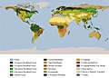
 Land cover IGBP.png 3,600 × 1,800; 1.79 MB
-
 Land cover mapping using TM images.jpg 3,292 × 1,108; 3.28 MB
-
 Landcover.jpg 231 × 346; 23 KB
-
 LULCCYCLE2LANDUSEANDLANDCOVER.jpg 1,366 × 768; 142 KB
-
 NASA 121557main landCover.jpg 2,702 × 1,939; 1.32 MB
-
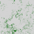 NLCD canopy MSN area.png 800 × 800; 106 KB
-
 NLCD impervious MSN area.png 800 × 800; 199 KB
-
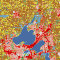 NLCD landcover MSN area.png 800 × 800; 107 KB
-
 NOAA STAR IGBP LandType.png 2,560 × 969; 246 KB


